Filter: Categories of Wisconsin Historical Images
Filter: FORMAT_TYPE of drawings
Filter: Creator Name of Lapham, Increase Allen
Filter: Categories of Wisconsin Historical Images
Filter: FORMAT_TYPE of drawings
Filter: Creator Name of Lapham, Increase Allen
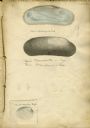
| Date: | 1828 |
|---|---|
| Description: | Increase Lapham's drawing of a Union mondonta (or Unio soleniformis) shell. There are also two views of another shell drawn below and a drawi... |

| Date: | 1828 |
|---|---|
| Description: | Increase Lapham drawings of Poa pratensis, Festuca duriuscula, Lolium prenne, Alopecurus pratensis, Anthoxanthum odoratum |

| Date: | 1840 |
|---|---|
| Description: | Map shows three Wisconsin territories, Jefferson, Waukesha, and Milwaukee. Map is ink, pencil, and watercolor on paper. Relief shown by hachures. |
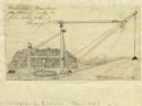
| Date: | 1827 |
|---|---|
| Description: | Increase Lapham's drawing of a rig designed by Mr. Orange Dibble for removing rocks and other large debris from deep canal cuts. |

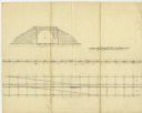
| Date: | 1828 |
|---|---|
| Description: | Drawing by Increase Lapham showing the geological profile of the land between Utica and Knob Creek, Kentucky at a scale of 1/2 inch to a mile. |
| Date: | 02 15 1830 |
|---|---|
| Description: | Increase Lapham's drawing of a railroad tunnel and railroad tracks. |

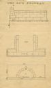
| Date: | 12 22 1830 |
|---|---|
| Description: | Increase Lapham's drawing of the geological profile between the Sandusky plains and Portsmouth, Ohio. |
If you didn't find the material you searched for, our Library Reference Staff can help.
Call our reference desk at 608-264-6535 or email us at: