Filter: Categories of Wisconsin Historical Images
Filter: FORMAT_TYPE of drawings
Filter: Creator Name of Lapham, Increase Allen
Filter: Categories of Wisconsin Historical Images
Filter: FORMAT_TYPE of drawings
Filter: Creator Name of Lapham, Increase Allen

| Date: | 1849 |
|---|---|
| Description: | Pencil sketch of a cross-section of the Dells of the Wisconsin River. People are in a row boat in the center. Caption at bottom: "The Dells — Wisconsin Riv... |
| Date: | |
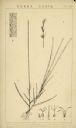
|---|---|
| Description: | Drawing by Increase Lapham of Carex Varia. It is a genus of plants in the family Cyperaceae, commonly known as sedges. Other members of the Cyperaceae fami... |
| Date: | |
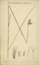
|---|---|
| Description: | Drawing by Increase Lapham of Eriophorum Gracile. It is a species of flowering plant in the sedge family, Cyperaceae. It is known by the common name slende... |
| Date: | |
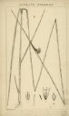
|---|---|
| Description: | Drawing by Increase Lapham of Scirpus Pungens. It is a species of flowering plant in the sedge family known by the common name Common Three-Square. It is a... |

| Date: | |
|---|---|
| Description: | Drawing by Increase Lapham of Carex Cyperaceae. Memebers of this family of plants are also called sedges, however those of genus Carex may be called "true"... |
| Date: | 1827 |
|---|---|
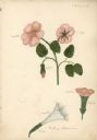
| Description: | Drawings of Datura Stramonium, more commonly known by the names jimson weed, devil's trumpet, devil's weed, thorn apple, tolguacha, Jamestown weed, stinkwe... |

| Date: | 1838 |
|---|---|
| Description: | This manuscript map, drawn in pencil, shows the lakes and rivers in the area between Lake of the Woods in northern Minnesota, the Mississippi River on the ... |

| Date: | 07 1868 |
|---|---|
| Description: | A hand-drawn map of a portion of Jackson County, Wisconsin between Township No. 21 north, range number 4 West and township no. 21 north, range no. 3 west, ... |

| Date: | 1840 |
|---|---|
| Description: | An ink, watercolor, and pencil on tracing paper, hand-drawn map of Milwaukee County, Wisconsin that shows the town and range system, sections, lakes and st... |

| Date: | 1844 |
|---|---|
| Description: | An ink on paper, hand-drawn map of Milwaukee County that shows the sectioning of townships, the boundary of the canal grant, roads, streams, lakes, includi... |

| Date: | 1837 |
|---|---|
| Description: | A pen and ink on tracing paper, hand-drawn and colored map the proposed route of the Milwaukee and Rock River Canal, ranging from the Rock River in the wes... |

| Date: | 1830 |
|---|---|
| Description: | An ink on paper, hand-drawn map of the town of Milwaukee, showing the divisions and landownership within the town by private individuals as well as those l... |

| Date: | 1875 |
|---|---|
| Description: | This manuscript map by Increase Lapham, drawn in the last year of his life, shows landownership, roads and railroads, springs, and boat houses around Ocono... |

| Date: | 1800 |
|---|---|
| Description: | This pen and ink drawing with watercolor shows the course of the Black River from Rock Creek, near Greenwood in Clark County, Wisconsin, to its confluence ... |

| Date: | 1864 |
|---|---|
| Description: | This map is pen and watercolor on paper and shows profile and geological formation of Blue Mound and location of Arnold’s Hotel and Brigham Lead Mines. |

| Date: | 1866 |
|---|---|
| Description: | This manuscript map by Increase Lapham shows the Dells of the Wisconsin River, from Stand Rock and Witches Gulch at the north to a point approximately one ... |

| Date: | 1836 |
|---|---|
| Description: | Pencil on tracing paper. Rough sketch of Milwaukee. Left top corner reads: "From Map of northern part of Illinois and the surveyed part of Wisconsin Territ... |
| Date: | 1828 |
|---|---|
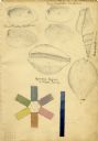
| Description: | Increase Lapham's drawings of Unio plicatus and Unio radiatum (?) from the Scioto River, Cypraea tigris (Tiger cowry), and an Atlantic... |
If you didn't find the material you searched for, our Library Reference Staff can help.
Call our reference desk at 608-264-6535 or email us at: