 Filter: Categories of Wisconsin Historical Images
Filter: FORMAT_TYPE of drawings
Filter: Type of Map or Atlas
Filter: Categories of Wisconsin Historical Images
Filter: FORMAT_TYPE of drawings
Filter: Type of Map or Atlas
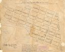
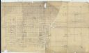
| Date: | 1840 |
|---|---|
| Description: | This map of La Crosse is ink and pencil on paper and shows lot and block numbers, as well as buildings. An inscription on the bottom of the map reads: "Tim... |

| Date: | 1880 |
|---|---|
| Description: | This map of the southern part of La Crosse is pen on cloth and shows proposed streets crossing the lands of Jane Usher and the Green Bay, Winona and St. Pa... |

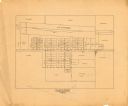
| Date: | 1800 |
|---|---|
| Description: | This map of North La Crosse is ink and pencil on paper and shows lot ownership and buildings. |

| Date: | 1850 |
|---|---|
| Description: | This map of the Town of Lake is ink and pencil on paper and shows lots and acreages, reserved land, and public squares. The bottom of the map includes a ke... |

| Date: | 1800 |
|---|---|
| Description: | This map of the Little Kaukalin Region is ink on paper and shows Little Kaukalin Rapids, Black Bird Island, buildings, trails, meadows and woods, and a sug... |

| Date: | 1857 |
|---|---|
| Description: | This map is ink and pencil on tracing paper. The map shows plats of a western section of Madison. The lakes are labeled "Fourth Lake", "Third Lake" and "La... |

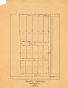
| Date: | |
|---|---|
| Description: | A hand-drawn map of Camp Curtis which was prepared for Colonel R. McMurphy. |

| Date: | 1872 |
|---|---|
| Description: | This map is pencil, ink, and watercolor on paper. Shown on the map is the elevation and profile of La Crescent Bottoms, Mt. Vernon Street line, 13th Street... |

| Date: | 1900 |
|---|---|
| Description: | The map is watercolor, pencil, and ink on tracing cloth and shows plats of both cities, local streets, railroads, mills, township divisions, bridges, and p... |

| Date: | 1902 |
|---|---|
| Description: | This map is watercolor and pen on paper and relief shown by contours. The map reads: "Contour interval 10 feet." Shown on the map are geological features a... |

| Date: | 1900 |
|---|---|
| Description: | This map is pencil on tracing paper and shows profiles of local streets. Sheet 6 is hand-colored and some sheets are missing. |

| Date: | 1856 |
|---|---|
| Description: | This map is ink and pencil on paper and shows plat of the town, local streets, and blocks and lots by number. The map includes explanatory text. |
| Date: | 1930 |
|---|---|
| Description: | This map is pen and pencil on paper and shows local streets, lots by number, and section divisions. |
| Date: | 1967 |
|---|---|
| Description: | This map is pen and pencil on paper and shows land ownership by name, blocks, lots, local streets, and railroads. To the right of the title the map reads: ... |

| Date: | 1834 |
|---|---|
| Description: | This map is pen, ink, and pencil on paper and shows plat of the town, local streets, mills, forts, hospitals, and parts of Devil River and Fox River. |

| Date: | 1900 |
|---|---|
| Description: | This map is pencil and ink on tracing cloth and shows local streets, railroads, harbor line, and part of Chequamegon Bay. |
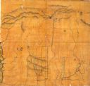
| Date: | 1835 |
|---|---|
| Description: | This map covers the Western Territory of the United States from the Rocky Mountains in Colorado south to Fort Smith, Arkansas, and from the Pacific Ocean e... |

| Date: | 1875 |
|---|---|
| Description: | This map oriented with the north to the upper left is ink, mounted on clothe. The depths of the water are shown by soundings. A handwritten inscription on ... |
| Date: | 1895 |
|---|---|
| Description: | This map is pencil and red ink on tracing paper and shows sold lots and some names of landowners. Handwritten annotations read: "SE 1/4 of NW 1/4 of sec. 2... |

| Date: | 1882 |
|---|---|
| Description: | This map is ink on cardboard and shows the location of military forts over the course of years. Also shown are points of interest, streets, the Mississippi... |
If you didn't find the material you searched for, our Library Reference Staff can help.
Call our reference desk at 608-264-6535 or email us at: