 Filter: Categories of Wisconsin Historical Images
Filter: FORMAT_TYPE of drawings
Filter: Type of Map or Atlas
Filter: Creator Name of Foster, Mary Stuart
Filter: Categories of Wisconsin Historical Images
Filter: FORMAT_TYPE of drawings
Filter: Type of Map or Atlas
Filter: Creator Name of Foster, Mary Stuart
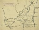
| Date: | 1922 |
|---|---|
| Description: | An ink on tracing paper, hand-drawn of south and eastern Wisconsin, illustrating the roads ranging from Dubuque, Iowa in the east to Green Bay, Wisconsin i... |
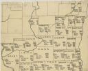
| Date: | 1922 |
|---|---|
| Description: | A hand-sketched map representing 1850 data of southern and eastern Wisconsin displaying the demographical breakouts for the counties in those areas, showin... |
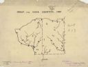
| Date: | 1927 |
|---|---|
| Description: | A hand-drawn map outlining the counties of Grant and Iowa counties as they would have appeared in 1837. |

| Date: | 1920 |
|---|---|
| Description: | An ink on tracing paper, hand-drawn map that shows lead mines, the boundary of the lead bearing strata, and the military road in Lafayette, Grant, Iowa, an... |

| Date: | 1972 |
|---|---|
| Description: | Ink on tracing paper. This map shows rivers, Prairie du Chien, site of Fort Crawford, Excelsior, Fort Andrew, Boscobel, Blue River, Orion, Muscoda, Castle ... |
If you didn't find the material you searched for, our Library Reference Staff can help.
Call our reference desk at 608-264-6535 or email us at: