 Filter: Categories of Wisconsin Historical Images
Filter: FORMAT_TYPE of digital file
Filter: Year of 1800-1899
Filter: Subject of lakes
Filter: Categories of Wisconsin Historical Images
Filter: FORMAT_TYPE of digital file
Filter: Year of 1800-1899
Filter: Subject of lakes

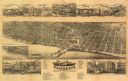
| Date: | 1870 |
|---|---|
| Description: | Bird's-eye map of Hudson, with insets of Court House and Public School. |
| Date: | 1883 |
|---|---|
| Description: | Bird's-eye map of Racine looking south west, with insets of points of interest. |

| Date: | 1890 |
|---|---|
| Description: | Bird's-eye view of Superior, Wisconsin. |

| Date: | 1892 |
|---|---|
| Description: | Color bird's-eye map of Wauwatosa, looking east toward Milwaukee and Lake Michigan. Predominantly green with cream colored roadways, with six land plots ow... |

| Date: | 1886 |
|---|---|
| Description: | Bird's-eye map of Baraboo with inset of Devil's Lake, the south and east sides of the commercial square, the First National Bank, and the Warren House hote... |
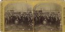
| Date: | 05 17 1870 |
|---|---|
| Description: | A large group, mainly men, are gathered behind the "Lake City Cornet Band" who are in uniform near a lake shore, possibly Lake Monona. The card was marked ... |
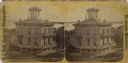
| Date: | 1877 |
|---|---|
| Description: | This building, on an entire block of Spaight and Brearly Streets with Lake Monona, was originally the governor's mansion for Leonard J. Farwell. The Farwel... |
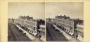
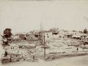
| Date: | 1870 |
|---|---|
| Description: | View overlooking Pinckney Street on the Square with the American Hotel in the background. |

| Date: | 1896 |
|---|---|
| Description: | This 1898 map shows the township and range system, sections, cities and villages, railroads, roads, vacant land and land sold by the Wisconsin Central Rail... |

| Date: | 1887 |
|---|---|
| Description: | City water works system map. Pencil annotation on the top right reads: "Period represented is after 1887 and before Aug. 1891". The middle of the map has a... |
| Date: | 1899 |
|---|---|
| Description: | Elevated view looking west over the open basements of commercial buildings which were destroyed by a recent fire. Main Street is in the foreground. Horse-d... |
If you didn't find the material you searched for, our Library Reference Staff can help.
Call our reference desk at 608-264-6535 or email us at: