 Filter: Categories of Wisconsin Historical Images
Filter: FORMAT_TYPE of digital file
Filter: Subject of water
Filter: Categories of Wisconsin Historical Images
Filter: FORMAT_TYPE of digital file
Filter: Subject of water
| Date: | 1997 |
|---|---|
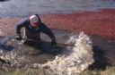
| Description: | A man wearing waders walks knee-deep through floating cranberries. The wooden boards floating in the water are booms to contain the cranberries for harvest... |
| Date: | 1997 |
|---|---|
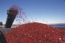
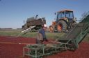
| Description: | Cranberries fly off of a conveyor belt onto a large pile in the back of a truck during harvest. |
| Date: | 1997 |
|---|---|
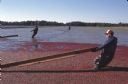
| Description: | Men positioning floating booms to confine the cranberries so they can be harvested. |
| Date: | 1997 |
|---|---|
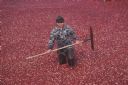
| Description: | A man stands waist-deep in water to harvest cranberries with a rake during the harvest. |
| Date: | 1997 |
|---|---|
| Description: | A man stands in the water next to the conveyor belt that transports cranberries into the truck. |
| Date: | 1997 |
|---|---|
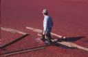
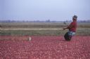
| Description: | Elevated view of harvesters wading through cranberries contained by booms to feed them onto a conveyor to be loaded into the waiting trucks. |
| Date: | 1997 |
|---|---|
| Description: | A man wearing waders walks knee-deep through water and floating cranberries as he pulls a boom used for confining the cranberries so they can be harvested. |
| Date: | 1997 |
|---|---|
| Description: | A man holding a rake wades knee-deep through floating cranberries during the harvest. |
| Date: | 1997 |
|---|---|
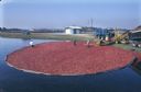
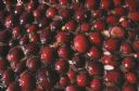
| Description: | Close-up of cranberries floating in the water during harvest. |

| Date: | 1896 |
|---|---|
| Description: | This 1898 map shows the township and range system, sections, cities and villages, railroads, roads, vacant land and land sold by the Wisconsin Central Rail... |

| Date: | 1930 |
|---|---|
| Description: | Aerial view, looking northeast, across Mud Lake with North Bay in the background, showing cultivated fields and wooded land. |

| Date: | 1930 |
|---|---|
| Description: | Aerial view looking north across the wooded peninsula separating Europe Bay (top) from Newport Bay. This area is now part of Newport State Park. |

| Date: | 1930 |
|---|---|
| Description: | Aerial view of the northern tip of the Door Peninsula, looking north. Europe Lake is in the center, with Europe Bay to the right. Plum Island and Washingto... |

| Date: | 1930 |
|---|---|
| Description: | Aerial view looking northeast, with Rowley's Bay in the foreground. Europe Lake is to the left, with Europe Bay and Newport Bay separated by a narrow peni... |

| Date: | 1930 |
|---|---|
| Description: | Aerial view over northern Door County, looking northeast across Europe Lake and Europe Bay toward Plum and Washington Islands. Farm fields and orchards con... |

| Date: | 1930 |
|---|---|
| Description: | Aerial view from over Moonlight Bay, looking east across Bues Point to Spike Horn Bay and Cana Island. The Cana Island Lighthouse is seen as a ship passes ... |

| Date: | 1930 |
|---|---|
| Description: | Aerial view, looking north, across the beach and pier on Europe Bay to Europe Lake and beyond to Washington Island. The land south (to the right) of Europe... |
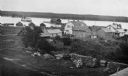
| Date: | 1915 |
|---|---|
| Description: | Elevated view of Fish Creek Harbor as a boat approaches the pier and warehouse. In the foreground are houses with outbuildings, gardens and a small orchard... |
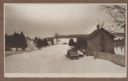
| Date: | 1915 |
|---|---|
| Description: | Winter scene from Egg Harbor Road (Highway 42) in Fish Creek looking north toward frozen Fish Creek Harbor with the bluffs in Peninsula State Park beyond. ... |
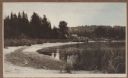
| Date: | 1915 |
|---|---|
| Description: | A rustic foot bridge over Fish Creek connects Peninsula State Park (foreground) with the village of Fish Creek. The Vits house is at the right end of the b... |
If you didn't find the material you searched for, our Library Reference Staff can help.
Call our reference desk at 608-264-6535 or email us at: