 Filter: Categories of Wisconsin Historical Images
Filter: FORMAT_TYPE of digital file
Filter: Subject of water
Filter: Subject of roads
Filter: Categories of Wisconsin Historical Images
Filter: FORMAT_TYPE of digital file
Filter: Subject of water
Filter: Subject of roads

| Date: | 1886 |
|---|---|
| Description: | Bird's-eye view of Bayfield, county seat of Bayfield County. On the lower left side is an inset for Bayfield and the Apostle Islands. |
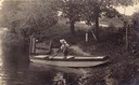
| Date: | |
|---|---|
| Description: | Laurie Peterson, son of the photographer, plays in boat. The photograph was originally titled "The Lone Boatsman". |

| Date: | 1890 |
|---|---|
| Description: | Bird's-eye map of Beloit with insets of Williams Engine Works, Eclipse Wind Engine Co., and John Foster & Co. Turtle Creek is in the lower section, and the... |

| Date: | 1857 |
|---|---|
| Description: | Elevated view of Waukesha with two women wearing dresses with a boy in long pants and tam o'shanter hat in foreground against a split-rail fence. Beyond th... |

| Date: | 1892 |
|---|---|
| Description: | Color bird's-eye map of Wauwatosa, looking east toward Milwaukee and Lake Michigan. Predominantly green with cream colored roadways, with six land plots ow... |
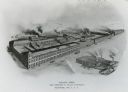
| Date: | 1900 |
|---|---|
| Description: | Main factory with South Foundry in lower left. Lake Michigan is in the background. Later the Allis-Chalmers Manufacturing Co. |
| Date: | 1870 |
|---|---|
| Description: | View overlooking Pinckney Street on the Square with the American Hotel in the background. |

| Date: | 1930 |
|---|---|
| Description: | The front and back of a postcard featuring a drawing of the Detroit skyline as seen from Windsor, Ontario that was sent by Alice and Floyd Quinney during t... |

| Date: | 06 28 1912 |
|---|---|
| Description: | Colorized postcard view of the rock formation called the Devil's Doorway in Devil's Lake State Park. Trees are growing among the rocks. The lake, bluffs, b... |

| Date: | 1896 |
|---|---|
| Description: | This 1898 map shows the township and range system, sections, cities and villages, railroads, roads, vacant land and land sold by the Wisconsin Central Rail... |
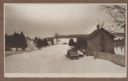
| Date: | 1915 |
|---|---|
| Description: | Winter scene from Egg Harbor Road (Highway 42) in Fish Creek looking north toward frozen Fish Creek Harbor with the bluffs in Peninsula State Park beyond. ... |

| Date: | 1915 |
|---|---|
| Description: | An older story and a half wood frame house with a one-story addition on the left and lean-to on the right stands near the Green Bay shore. It is identified... |

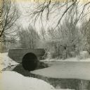
| Date: | 08 1981 |
|---|---|
| Description: | This bridge, over the Rock River was later replaced. |
| Date: | 07 2014 |
|---|---|
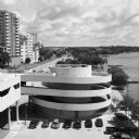
| Description: | View from the top level of Monona Terrace towards the spiral ramp leading to the outdoor parking lot. Just beyond is John Nolen Drive and railroad tracks. ... |
| Date: | 1940 |
|---|---|
| Description: | View from snowy shoreline towards a bridge over Wingra Creek, between Lake Wingra and Lake Monona, in Vilas Park. The road over the bridge leads into the U... |

| Date: | |
|---|---|
| Description: | Two Harley-Davidson motorcycles are parked next to a sidewalk on the side of a dirt road. Just behind the motorcycles are a man and two women standing toge... |
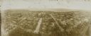
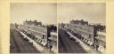
| Date: | 1908 |
|---|---|
| Description: | Kite aerial panoramic photograph of the central business district. In the distance is Lake Mendota. The fire damaged Wisconsin State Capitol is in the cent... |
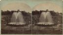
| Date: | |
|---|---|
| Description: | Stereograph of Artesian well. A stone wall surrounds the well, with an observation area beyond. Groups of visitors are milling about and a drive with horse... |
If you didn't find the material you searched for, our Library Reference Staff can help.
Call our reference desk at 608-264-6535 or email us at: