 Filter: Categories of Wisconsin Historical Images
Filter: FORMAT_TYPE of digital file
Filter: Subject of transportation
Filter: Subject of land
Filter: Categories of Wisconsin Historical Images
Filter: FORMAT_TYPE of digital file
Filter: Subject of transportation
Filter: Subject of land

| Date: | 1886 |
|---|---|
| Description: | Bird's-eye view of Bayfield, county seat of Bayfield County. On the lower left side is an inset for Bayfield and the Apostle Islands. |

| Date: | 1868 |
|---|---|
| Description: | This 1868 birds-eye view depicts the buildings, streets, railroad, vegetation and topography of Columbus, Wisconsin. The high school, cemetery, railroad de... |

| Date: | 1870 |
|---|---|
| Description: | Bird's-eye map of Hudson, with insets of Court House and Public School. |

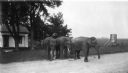
| Date: | |
|---|---|
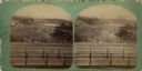
| Description: | Two men stand in a field with a dog, several cows, and a man in a horse-drawn buggy. In the far distance is Blue Mounds. |
| Date: | |
|---|---|
| Description: | Elevated view of St. Anthony's Fall. Caption on back of stereograph reads, "St. Anthony's Falls, Minneapolis, Minn." There is a bridge in the foreground, a... |
| Date: | |
|---|---|
| Description: | Elevated view of the north end of Devil's Lake and Cliff House. A number of buildings are around the shoreline with railroad tracks in the foreground. A lo... |

| Date: | 06 28 1912 |
|---|---|
| Description: | Colorized postcard view of the rock formation called the Devil's Doorway in Devil's Lake State Park. Trees are growing among the rocks. The lake, bluffs, b... |

| Date: | 1970 |
|---|---|
| Description: | Migrant farm workers harvesting tomatoes in the Rio Grande Valley. Obreros Unidos (United Workers) grew in Wisconsin during the 1960s and had deep roots ... |

| Date: | 1930 |
|---|---|
| Description: | Aerial view from over Moonlight Bay, looking east across Bues Point to Spike Horn Bay and Cana Island. The Cana Island Lighthouse is seen as a ship passes ... |

| Date: | 1930 |
|---|---|
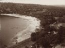
| Description: | Aerial view, looking north, across the beach and pier on Europe Bay to Europe Lake and beyond to Washington Island. The land south (to the right) of Europe... |
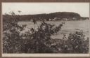
| Date: | 1915 |
|---|---|
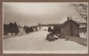
| Description: | Winter scene from Egg Harbor Road (Highway 42) in Fish Creek looking north toward frozen Fish Creek Harbor with the bluffs in Peninsula State Park beyond. ... |
| Date: | 1915 |
|---|---|
| Description: | A rustic foot bridge over Fish Creek connects Peninsula State Park (foreground) with the village of Fish Creek. The Vits house is at the right end of the b... |
| Date: | 1912 |
|---|---|
| Description: | View looking west from the Hotz property on Fish Creek Beach. The Thorp bathhouse is on the left, with the Welcker bathhouses beyond. There are houses an... |
| Date: | 1915 |
|---|---|
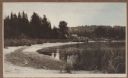
| Description: | View of Fish Creek from Weborg's Point in Peninsula State Park. The Fish Creek dock with barnlike warehouse is in center right. Behind the dock is the two-... |
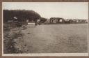
| Date: | 1920 |
|---|---|
| Description: | Three elephants on the side of the road near Holloway Farm. Two of the elephants are chained together. They may have been circus animals going from one tow... |
| Date: | 1945 |
|---|---|
| Description: | A threshing scene in a field. One man pitches grain into a threshing machine while standing on the load of grain in the wagon pulled by two horses. A secon... |
| Date: | 1945 |
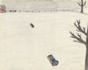
|---|---|
| Description: | Two boys sled down a snow covered hillside at the farm. Two leafless trees are on the right. Along the horizon is a red building on the left with a fence s... |
| Date: | 1999 |
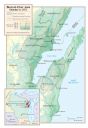
|---|---|
| Description: | Map depicting the burned over area created by the fire on October 8, 1871. Map includes inset of Wisconsin and surrounding states with detail of area impac... |

| Date: | 09 1957 |
|---|---|
| Description: | The Zastrow wedding party is shown on their way to the Mayville Park Pavilion. Locals will recognize this hill on the Mayville Road before it was leveled o... |

| Date: | 09 1957 |
|---|---|
| Description: | Loehrke/Zastrow wedding. The Mayville Park Pavilion is reflected in the Rock River. |
If you didn't find the material you searched for, our Library Reference Staff can help.
Call our reference desk at 608-264-6535 or email us at: