 Filter: Categories of Wisconsin Historical Images
Filter: FORMAT_TYPE of digital file
Filter: Subject of state parks and reserves
Filter: Categories of Wisconsin Historical Images
Filter: FORMAT_TYPE of digital file
Filter: Subject of state parks and reserves
| Date: | |
|---|---|
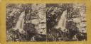
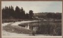
| Description: | Two men sit near Periwinkle Falls. The falls are surrounded by ferns and other foliage. |

| Date: | |
|---|---|
| Description: | A view of the shoreline of Devil's Lake with railroad tracks in the foreground. On the back of the photograph is the photographer's information: "Sim Mould... |
| Date: | |
|---|---|
| Description: | Elevated view of the north end of Devil's Lake and Cliff House. A number of buildings are around the shoreline with railroad tracks in the foreground. A lo... |
| Date: | |
|---|---|
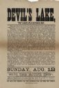
| Description: | Advertisement for a train trip to Devil's Lake. The trip originates in Elgin, Illinios, with pick-ups in East Elgin, Dundee, Carpenterville and Algonquin. ... |

| Date: | |
|---|---|
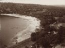
| Description: | View from shoreline of Devil's Lake with the far shoreline in the background. |

| Date: | |
|---|---|
| Description: | Elevated view of Devil's Lake from the top of the bluffs, talus slope visible on right. |

| Date: | |
|---|---|
| Description: | Elevated view of Devil's Lake from the top of the bluffs, talus slope visible on right. |

| Date: | |
|---|---|
| Description: | Entrance to Cold Water Canyon near Wisconsin Dells. In the foreground is a wooden walkway across the water. |

| Date: | 1952 |
|---|---|
| Description: | The famous Dells of the Wisconsin River. A souvenir map embellished with bits of history and points of interest. |

| Date: | 06 28 1912 |
|---|---|
| Description: | Colorized postcard view of the rock formation called the Devil's Doorway in Devil's Lake State Park. Trees are growing among the rocks. The lake, bluffs, b... |

| Date: | 1965 |
|---|---|
| Description: | Color postcard view of the rock formation called Tomahawk Rock in Devil's Lake State Park. The lake and beach, trees, bluffs and sky are visible in the bac... |

| Date: | 1930 |
|---|---|
| Description: | Aerial view looking north across the wooded peninsula separating Europe Bay (top) from Newport Bay. This area is now part of Newport State Park. |

| Date: | 1930 |
|---|---|
| Description: | Aerial view of the northern tip of the Door Peninsula, looking north. Europe Lake is in the center, with Europe Bay to the right. Plum Island and Washingto... |

| Date: | 1930 |
|---|---|
| Description: | Aerial view looking northeast, with Rowley's Bay in the foreground. Europe Lake is to the left, with Europe Bay and Newport Bay separated by a narrow peni... |

| Date: | 1930 |
|---|---|
| Description: | Aerial view over northern Door County, looking northeast across Europe Lake and Europe Bay toward Plum and Washington Islands. Farm fields and orchards con... |

| Date: | 1930 |
|---|---|
| Description: | Aerial view, looking north, across the beach and pier on Europe Bay to Europe Lake and beyond to Washington Island. The land south (to the right) of Europe... |
| Date: | 1915 |
|---|---|
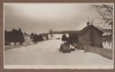
| Description: | Winter scene from Egg Harbor Road (Highway 42) in Fish Creek looking north toward frozen Fish Creek Harbor with the bluffs in Peninsula State Park beyond. ... |
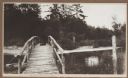
| Date: | 1915 |
|---|---|
| Description: | A rustic foot bridge over Fish Creek connects Peninsula State Park (foreground) with the village of Fish Creek. The Vits house is at the right end of the b... |
| Date: | 1915 |
|---|---|
| Description: | View from the Vits property, looking east, across a rustic foot bridge over Fish Creek leading to Peninsula State Park. A dachshund rests in the middle of ... |

| Date: | 1915 |
|---|---|
| Description: | Elevated view, looking north, from the Hotz family compound near the bluff entrance to Fish Creek. Evergreens and bare birch trees stand in the foreground,... |
If you didn't find the material you searched for, our Library Reference Staff can help.
Call our reference desk at 608-264-6535 or email us at: