Filter: Categories of Wisconsin Historical Images
Filter: FORMAT_TYPE of digital file
Filter: Subject of rivers
Filter: Categories of Wisconsin Historical Images
Filter: FORMAT_TYPE of digital file
Filter: Subject of rivers

| Date: | 1890 |
|---|---|
| Description: | Bird's-eye map of Beloit with insets of Williams Engine Works, Eclipse Wind Engine Co., and John Foster & Co. Turtle Creek is in the lower section, and the... |

| Date: | 1867 |
|---|---|
| Description: | Bird's-eye map of Berlin, with insets of West Side Public School and High School. |

| Date: | 1907 |
|---|---|
| Description: | Bird's-eye map of Chippewa Falls with insets of Chippewa Lumber & Boom Co., Opera House Block, Chippewa Falls Furniture Co., and J. Leinenkugel Brewing Co. |

| Date: | 1868 |
|---|---|
| Description: | This 1868 birds-eye view depicts the buildings, streets, railroad, vegetation and topography of Columbus, Wisconsin. The high school, cemetery, railroad de... |

| Date: | 1870 |
|---|---|
| Description: | Bird's-eye map of Hudson, with insets of Court House and Public School. |

| Date: | 1850 |
|---|---|
| Description: | Bird's-eye view of business district of Oshkosh, "drawn after nature" by the artist. |

| Date: | 1874 |
|---|---|
| Description: | Bird's-eye map of Reedsburg, on the Baraboo River. |

| Date: | 1867 |
|---|---|
| Description: | Bird's-eye map of Watertown on the Rock River, "drawn from nature." |

| Date: | 1857 |
|---|---|
| Description: | Elevated view of Waukesha with two women wearing dresses with a boy in long pants and tam o'shanter hat in foreground against a split-rail fence. Beyond th... |

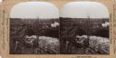
| Date: | 1886 |
|---|---|
| Description: | Bird's-eye map of Baraboo with inset of Devil's Lake, the south and east sides of the commercial square, the First National Bank, and the Warren House hote... |
| Date: | 1934 |
|---|---|
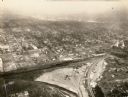
| Description: | Aerial view of Janesville showing the river fill for the new sewerage disposal plant. |

| Date: | 1898 |
|---|---|
| Description: | View from water tower, showing the grove where Black Hawk's pursuers were supposed to have camped in 1832. The group of men in the foreground are digging f... |
| Date: | 1969 |
|---|---|
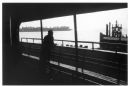
| Description: | The Island's Edge, Williamsburg Bridge, East River. |
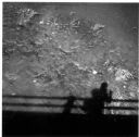
| Date: | 1992 |
|---|---|
| Description: | Self-Portrait of shadow from Lucinda Bridge above the Kishwaukee River. |
| Date: | 1904 |
|---|---|
| Description: | A view looking west over water toward the Fox River dam at Montello. There is granite riprap on the left. A boat with a small sail is in the background. T... |
| Date: | 06 12 1899 |
|---|---|
| Description: | Elevated view of a town with a railroad bridge crossing over a river. Several individuals are visible crossing the bridge. Sign near bridge says: "Willow R... |
If you didn't find the material you searched for, our Library Reference Staff can help.
Call our reference desk at 608-264-6535 or email us at: