 Filter: Categories of Wisconsin Historical Images
Filter: FORMAT_TYPE of digital file
Filter: Subject of indian reservations
Filter: Categories of Wisconsin Historical Images
Filter: FORMAT_TYPE of digital file
Filter: Subject of indian reservations

| Date: | 1896 |
|---|---|
| Description: | This 1898 map shows the township and range system, sections, cities and villages, railroads, roads, vacant land and land sold by the Wisconsin Central Rail... |

| Date: | 1977 |
|---|---|
| Description: | Frances Decorah and her son Patrick at a Pow-wow in South Dakota. She is seated in a lawn chair and Patrick is napping on her lap. Frances is wearing stree... |
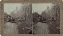
| Date: | |
|---|---|
| Description: | Stereograph of two Menomonee Indian family groups in horse-drawn wagons. One boy is standing next to a wagon and a man is standing on the right holding a g... |
If you didn't find the material you searched for, our Library Reference Staff can help.
Call our reference desk at 608-264-6535 or email us at: