 Filter: Categories of Wisconsin Historical Images
Filter: FORMAT_TYPE of digital file
Filter: Subject of human settlements
Filter: Categories of Wisconsin Historical Images
Filter: FORMAT_TYPE of digital file
Filter: Subject of human settlements
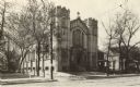
| Date: | 1910 |
|---|---|
| Description: | St. Paul's University Chapel at 723 State Street. |
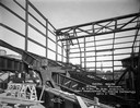
| Date: | 04 02 1927 |
|---|---|
| Description: | View of the early construction of the Capitol Theatre showing the steel frame of the building. |

| Date: | 1886 |
|---|---|
| Description: | Bird's-eye view of Bayfield, county seat of Bayfield County. On the lower left side is an inset for Bayfield and the Apostle Islands. |
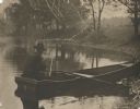
| Date: | |
|---|---|
| Description: | View from shoreline of the photographer, Carl A. Peterson, taking a moment to light his pipe while fishing from a boat near the family home. |
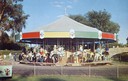
| Date: | |
|---|---|
| Description: | Children riding the carousel (merry-go-round) at Henry Vilas Zoo (Vilas Park Zoo), donated by the citizens of the Madison area. A stone bridge is in the ba... |
| Date: | 1965 |
|---|---|
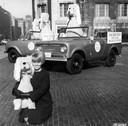
| Description: | Woman posing with "Cuddly Dudley" stuffed animals (dogs) and International Scout pickups as part of a promotional campaign. A sign on each Scout reads: "O... |

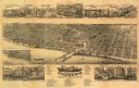
| Date: | 1890 |
|---|---|
| Description: | Bird's-eye map of Beloit with insets of Williams Engine Works, Eclipse Wind Engine Co., and John Foster & Co. Turtle Creek is in the lower section, and the... |

| Date: | 1867 |
|---|---|
| Description: | Bird's-eye map of Berlin, with insets of West Side Public School and High School. |

| Date: | 1907 |
|---|---|
| Description: | Bird's-eye map of Chippewa Falls with insets of Chippewa Lumber & Boom Co., Opera House Block, Chippewa Falls Furniture Co., and J. Leinenkugel Brewing Co. |

| Date: | 1868 |
|---|---|
| Description: | This 1868 birds-eye view depicts the buildings, streets, railroad, vegetation and topography of Columbus, Wisconsin. The high school, cemetery, railroad de... |

| Date: | 1870 |
|---|---|
| Description: | Bird's-eye map of Hudson, with insets of Court House and Public School. |

| Date: | 1873 |
|---|---|
| Description: | Bird's-eye map of La Crosse from the Mississippi River. |

| Date: | 1906 |
|---|---|
| Description: | Bird's-eye map of South Milwaukee. |

| Date: | 1850 |
|---|---|
| Description: | Bird's-eye view of business district of Oshkosh, "drawn after nature" by the artist. |
| Date: | 1886 |
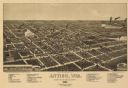
|---|---|
| Description: | Bird's-eye map of Antigo, county Seat of Langlade County, population 2500. |
| Date: | 1883 |
|---|---|
| Description: | Bird's-eye map of Racine looking south west, with insets of points of interest. |

| Date: | 1874 |
|---|---|
| Description: | Bird's-eye map of Reedsburg, on the Baraboo River. |

| Date: | 1890 |
|---|---|
| Description: | Bird's-eye view of Superior, Wisconsin. |
If you didn't find the material you searched for, our Library Reference Staff can help.
Call our reference desk at 608-264-6535 or email us at:

