 Filter: Categories of Wisconsin Historical Images
Filter: FORMAT_TYPE of architectural drawings
Filter: Year of 1800-1899
Filter: Year of 1890-1899
Filter: Categories of Wisconsin Historical Images
Filter: FORMAT_TYPE of architectural drawings
Filter: Year of 1800-1899
Filter: Year of 1890-1899

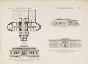
| Date: | 1896 |
|---|---|
| Description: | Front elevation and floor plans submitted by Milwaukee architect, H. C.Koch & Co., for the Wisconsin Historical Society building design competition. The b... |
| Date: | 1896 |
|---|---|
| Description: | Unsuccessful elevations and floor plans submitted by Peabody & Stearns, of Boston, and Charles S. Frost, of Chicago, as part of the design competition for ... |
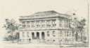
| Date: | 1899 |
|---|---|
| Description: | Copy of an artist's rendition of an exterior view of the Elisha D. Smith Library. Pen and ink drawing is signed: "G.J. de Gelleke, 1899." Bottom of drawing... |

| Date: | 1897 |
|---|---|
| Description: | Topographical map of Stanley McCormick's Riven Rock estate in El Montecito, Santa Barbara County, California. The map is identified as a map of a survey co... |

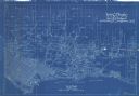
| Date: | 1899 |
|---|---|
| Description: | Topographical map showing ridges, water courses, boundary lines, and trails and roads near the Stanley McCormick's Riven Rock estate in El Montecito, Santa... |
| Date: | 1899 |
|---|---|
| Description: | Map of the Santa Barbara Channel California area showing property boundaries and some geographical features. The Riven Rock Estate has been outlined in yel... |
| Date: | 1899 |
|---|---|
| Description: | Architectural drawing of the East Elevation of the terrace at Riven Rock, Stanley McCormick's estate in El Montecito, Santa Barbara County, California. The... |

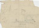
| Date: | 1899 |
|---|---|
| Description: | Overhead map of the Stanley McCormick's Riven Rock estate in El Montecito, Santa Barbara, California. The map shows the placement of dwellings and fields, ... |

| Date: | 1899 |
|---|---|
| Description: | A map showing the shoreline of a portion of El Montecito, Santa Barbara County, California. The map shows properties along the Pacific Ocean, and may have ... |
If you didn't find the material you searched for, our Library Reference Staff can help.
Call our reference desk at 608-264-6535 or email us at: