 Filter: Categories of Wisconsin Historical Images
Filter: FORMAT_TYPE of architectural drawings
Filter: Subject of transportation
Filter: Categories of Wisconsin Historical Images
Filter: FORMAT_TYPE of architectural drawings
Filter: Subject of transportation
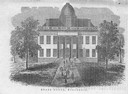
| Date: | 1856 |
|---|---|
| Description: | The Wisconsin State Capitol (the second State Capitol, the first in Madison). Illustration from the American Encyclopedia, Columbus, 1859. |
| Date: | 01 09 1940 |
|---|---|
| Description: | Blueprint design for a suspension footbridge for Copper Falls State Park. |

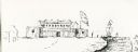
| Date: | 1855 |
|---|---|
| Description: | Detail from a lithograph vignette on a Map of the City of Madison of the third Wisconsin State Capitol, the first Capitol in Madison. |
| Date: | |
|---|---|
| Description: | View of a fort with fortified walls and a flag flying from the fort. A river runs on the right of the image. A boat with sails floats on the river. Sold... |

| Date: | 05 1956 |
|---|---|
| Description: | Perspective drawing of the Sy Dolnick Residence, "Woodwind," designed by John Randal McDonald. |
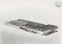
| Date: | 1961 |
|---|---|
| Description: | Three-dimensional drawing of Miller Electric Manufacturing Co. viewed from above. A small circle is made on the image in pen on the front of the building. |

| Date: | 02 14 1939 |
|---|---|
| Description: | Deatiled blueprint (pg 2) for the suspension footbridge in Copper Falls State Park. |
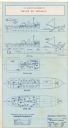
| Date: | 12 14 1939 |
|---|---|
| Description: | Page 1 of detailed blueprints for the suspension footbridge in Copper Falls State Park. |

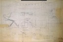
| Date: | 02 12 1946 |
|---|---|
| Description: | Blueprints details for Signs and Markers for Copper Falls State Park. |
| Date: | 1953 |
|---|---|
| Description: | Interior perspective drawing of the living room of the Fred Graber house designed and drawn by architect John Randal McDonald. |

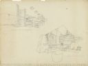
| Date: | 1949 |
|---|---|
| Description: | Exterior elevation drawing of the Goulais house designed and drawn by architect John Randal McDonald. The drawing shows the proposed new chimney, north wal... |
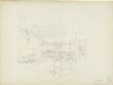
| Date: | 1952 |
|---|---|
| Description: | Interior perspectives of the Robert Johns residence designed and drawn by architect John Randal McDonald. McDonald gave the project two names, "Spindrift"... |

| Date: | 1956 |
|---|---|
| Description: | Pencil on vellum drawing showing an interior perspective of the living room/balcony space and an exterior perspective of the residence designed and drawn b... |

| Date: | 1897 |
|---|---|
| Description: | Topographical map of Stanley McCormick's Riven Rock estate in El Montecito, Santa Barbara County, California. The map is identified as a map of a survey co... |

| Date: | 1899 |
|---|---|
| Description: | Topographical map showing ridges, water courses, boundary lines, and trails and roads near the Stanley McCormick's Riven Rock estate in El Montecito, Santa... |

| Date: | 1899 |
|---|---|
| Description: | Overhead map of the Stanley McCormick's Riven Rock estate in El Montecito, Santa Barbara, California. The map shows the placement of dwellings and fields, ... |

| Date: | 1899 |
|---|---|
| Description: | A map showing the shoreline of a portion of El Montecito, Santa Barbara County, California. The map shows properties along the Pacific Ocean, and may have ... |
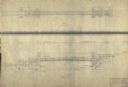
| Date: | 06 09 1986 |
|---|---|
| Description: | A blueprint prepared for Emile de Antonio by the de Pavloff Company in San Francisco. The blueprint is a rendering of "Rainbow Warrior II," a proposed nava... |

| Date: | 06 08 1960 |
|---|---|
| Description: | Blueprint plat of Sunset Hills sub-division. |
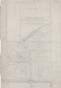
| Date: | 1938 |
|---|---|
| Description: | Architectural drawing of the Sunset Village neighborhood on the West side of the city of Madison. The poster description reads: A proposed master plan for ... |
If you didn't find the material you searched for, our Library Reference Staff can help.
Call our reference desk at 608-264-6535 or email us at: