 Filter: Categories of Wisconsin Historical Images
Filter: FORMAT_NUMBER_ORG of Road Maps, Box 14
Filter: Year of 1900-1999
Filter: Year of 1940-1949
Filter: Categories of Wisconsin Historical Images
Filter: FORMAT_NUMBER_ORG of Road Maps, Box 14
Filter: Year of 1900-1999
Filter: Year of 1940-1949
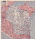
| Date: | 1942 |
|---|---|
| Description: | This colored road map shows automobile roads in Wisconsin as well as portions of nearby states. Information on the quality and type of any road shown (pave... |

| Date: | 1946 |
|---|---|
| Description: | This colored road map shows automobile roads in Wisconsin as well as portions of nearby states. Information on the quality and type of any road shown (Inte... |

| Date: | 1948 |
|---|---|
| Description: | This colored road map shows automobile roads in Wisconsin as well as portions of nearby states.Information on the quality and type of any road shown (bitum... |

| Date: | 1948 |
|---|---|
| Description: | This colored road map shows automobile roads in Wisconsin as well as portions of nearby states. The map is organized such that a single map of Wisconsin is... |

| Date: | 1948 |
|---|---|
| Description: | This colored road map shows automobile roads in Wisconsin as well as portions of nearby states. The map is organized such that a single map of Wisconsin is... |

| Date: | 1949 |
|---|---|
| Description: | This multi-colored promotional map for recreational activities in the Hayward area includes a graphic of distances from Midwestern cities to Hayward, with ... |
If you didn't find the material you searched for, our Library Reference Staff can help.
Call our reference desk at 608-264-6535 or email us at: