Filter: Categories of Wisconsin Historical Images
Filter: FORMAT_NUMBER_ORG of PH 7051
Filter: Subject of water
Filter: Categories of Wisconsin Historical Images
Filter: FORMAT_NUMBER_ORG of PH 7051
Filter: Subject of water

| Date: | 1910 |
|---|---|
| Description: | View across water towards a bark canoe resting at an Indian camp on the shore of Lac La Croix. There are several dogs at the camp. |
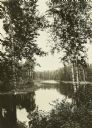
| Date: | 1910 |
|---|---|
| Description: | A view from shore of Lac La Croix. The still surface of the lake creates a mirror-like reflection of trees on the water. |

| Date: | 1910 |
|---|---|
| Description: | Carl standing outdoors eating food from a plate he is holding. There is a lake in the background beyond rocks and trees. |

| Date: | 1910 |
|---|---|
| Description: | The Gang stopping at Sand Point for a lunch break. The canoes are at the edge of the shoreline, while everyone is sitting on the ground eating. The canoe o... |

| Date: | 1910 |
|---|---|
| Description: | A view from the water of several buildings along the shoreline in Kettle Falls. |
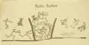
| Date: | 1910 |
|---|---|
| Description: | Carl's humorous drawing depicting The Gang as stick figures in three panels. Di the dog is also featured and is more completely drawn. |

| Date: | 1910 |
|---|---|
| Description: | Bill Marr, on the left, and Howard "Dad" Greene washing their clothes with soap on a rock by the lake. |

| Date: | 1910 |
|---|---|
| Description: | Rear view across water towards Billy Mac and another of The Gang paddling a canoe on a lake. The men have changed into a reserved set of travel clothes so ... |

| Date: | 1910 |
|---|---|
| Description: | A view from the water of Rocky Island on Rainy Lake. |
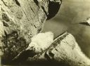
| Date: | 1910 |
|---|---|
| Description: | A young bird in a rock crevice on Rocky Island. The island is on Rainy Lake. |

| Date: | |
|---|---|
| Description: | A blueprint of a map of a portion of Ashland County. |

| Date: | |
|---|---|
| Description: | A blueprint map of a portion of Chippewa County. |
| Date: | |
|---|---|
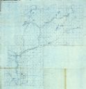
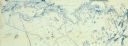
| Description: | A detailed blueprint map showing the route of Howard Greene and The Gang's canoe trip through the Rainy Lake region in 1910. |
| Date: | 1911 |
|---|---|
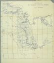
| Description: | A map of St. Louis County, Minnesota that traces the route of Howard Green and The Gang's canoe trip from Tower to Ranier. |
| Date: | |
|---|---|
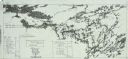
| Description: | A blueprint map with an overlay traced in pencil of the routes of Howard Greene and The Gang's 1910 and 1911 canoe trips. |

| Date: | 1910 |
|---|---|
| Description: | Billy Mac wearing a backpack while standing on rocks. He is holding a fishing pole, and another person is sitting on a rock near water in the background. |
If you didn't find the material you searched for, our Library Reference Staff can help.
Call our reference desk at 608-264-6535 or email us at: