Filter: Categories of Wisconsin Historical Images
Filter: FORMAT_NUMBER_ORG of PH 6445
Filter: Year of 1900-1999
Filter: Categories of Wisconsin Historical Images
Filter: FORMAT_NUMBER_ORG of PH 6445
Filter: Year of 1900-1999
| Date: | 02 12 1970 |
|---|---|
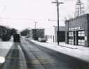
| Description: | State Highway 51 in Iola, Wisconsin, primarily showing the Fire Department and its siren. |

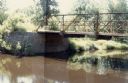
| Date: | 09 1982 |
|---|---|
| Description: | Nollenberg Road Bridge in the Town of Union. |

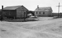
| Date: | 1967 |
|---|---|
| Description: | The Clark Oil Company station at the corner of State Highway 73 & 21 and Baxter Avenue. |

| Date: | 01 15 1985 |
|---|---|
| Description: | Mecan River bridge on County Highway N over the Mecan River in rural Marquette County. |
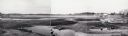
| Date: | 1958 |
|---|---|
| Description: | Plover River Pond; the dam was out and the pond is dry, permitting an unusual view of the immediate area. Highway 51 and a bridge can be seen in the distan... |
| Date: | 12 14 1982 |
|---|---|
| Description: | View from the southwest looking toward an old bridge over Rocky Creek, in the Town of Wood, Wood County. A farm is visible in the distance. |
| Date: | 06 06 1981 |
|---|---|
| Description: | Panoramic view of the north side of the old bridge over Rocky Run in the Town of Hiles, Wood County, Wisconsin. |

| Date: | 1992 |
|---|---|
| Description: | A John Deere company commercial being shot on the streets of Horicon, Wisconsin. The parade celebrated the 2,000,000 lawn and grounds care products to com... |

| Date: | 03 1963 |
|---|---|
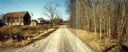
| Description: | Panoramic landscape view of the Fey Farm near Dexterville, Wood County. The view incudes the farmstead and much of the surrounding acreage and woodlands. T... |

| Date: | 11 09 1982 |
|---|---|
| Description: | View of the Lemonweire River Crossing in the town of Orange, Juneau County. |

| Date: | 07 21 1972 |
|---|---|
| Description: | A section of the Wisconsin Interstate I-90/94 in Juneau County as most motorists know it - through the windshield. |
| Date: | 06 01 1966 |
|---|---|
| Description: | Highway County CTH "N" looking southeast. The white building on the right is the Marathon Town Hall. |

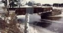
| Date: | 11 29 1989 |
|---|---|
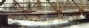
| Description: | Panoramic view of the Union Street Bridge in the village of Rosholt created by taping three images together. |

| Date: | 11 30 1989 |
|---|---|
| Description: | Panoramic view of the bridge over the frozen Eau Claire River. |
| Date: | 11 16 1989 |
|---|---|
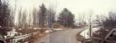
| Description: | McNinch Road, an unpaved road near the Little Wolf River crossing in the town of Wyoming. |
| Date: | 11 16 1989 |
|---|---|
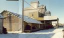
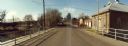
| Description: | View from the Water Street Bridge over the Waupaca River toward the Waupaca Water Department. |
If you didn't find the material you searched for, our Library Reference Staff can help.
Call our reference desk at 608-264-6535 or email us at: