Filter: Categories of Wisconsin Historical Images
Filter: FORMAT_NUMBER_ORG of PH 6445
Filter: Year of 1900-1999
Filter: Subject of transportation
Filter: Categories of Wisconsin Historical Images
Filter: FORMAT_NUMBER_ORG of PH 6445
Filter: Year of 1900-1999
Filter: Subject of transportation
| Date: | 03 21 1986 |
|---|---|
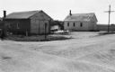
| Description: | Office and metal warehouse of Potato World, Inc., located on County Highway E near Grand Marsh in Adams County. |
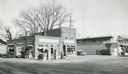
| Date: | 1957 |
|---|---|
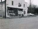
| Description: | Skelly service station, restaurant, and motel located along STH 12 in Mauston, Wisconsin. |
| Date: | 12 12 1973 |
|---|---|
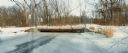
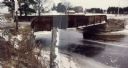
| Description: | Neenah Creek Bridge in Marquette County. |

| Date: | 11 29 1989 |
|---|---|
| Description: | Old bridge over Mill Creek on Highway G in Portage County. |

| Date: | 10 11 1973 |
|---|---|
| Description: | On a rainy day a Gardners' Bakery truck makes a delivery to Miller's Corner IGA Grocery Store on STH 153. |

| Date: | 05 21 1968 |
|---|---|
| Description: | Rural tavern and gasoline station on STH 54. |
| Date: | 1967 |
|---|---|
| Description: | Waupaca Tree Service at the intersection of STH 24 and King Road with station wagon parked in front. |
| Date: | 1967 |
|---|---|
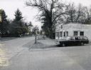
| Description: | Carlson's One Stop Market located on STH 22. |

| Date: | 03 28 1969 |
|---|---|
| Description: | Stone bridge over Two Mile Creek in Wood County. The creek is not frozen although the ground is snow-covered. |
| Date: | 02 12 1970 |
|---|---|
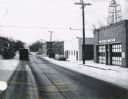
| Description: | State Highway 51 in Iola, Wisconsin, primarily showing the Fire Department and its siren. |

| Date: | 09 1982 |
|---|---|
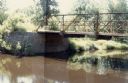
| Description: | Nollenberg Road Bridge in the Town of Union. |

| Date: | 1967 |
|---|---|
| Description: | The Clark Oil Company station at the corner of State Highway 73 & 21 and Baxter Avenue. |
| Date: | 01 15 1985 |
|---|---|
| Description: | Mecan River bridge on County Highway N over the Mecan River in rural Marquette County. |
| Date: | 1958 |
|---|---|
| Description: | Plover River Pond; the dam was out and the pond is dry, permitting an unusual view of the immediate area. Highway 51 and a bridge can be seen in the distan... |
| Date: | 12 14 1982 |
|---|---|
| Description: | View from the southwest looking toward an old bridge over Rocky Creek, in the Town of Wood, Wood County. A farm is visible in the distance. |
| Date: | 06 06 1981 |
|---|---|
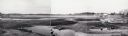
| Description: | Panoramic view of the north side of the old bridge over Rocky Run in the Town of Hiles, Wood County, Wisconsin. |

| Date: | 11 09 1982 |
|---|---|
| Description: | View of the Lemonweire River Crossing in the town of Orange, Juneau County. |

| Date: | 07 21 1972 |
|---|---|
| Description: | A section of the Wisconsin Interstate I-90/94 in Juneau County as most motorists know it - through the windshield. |
| Date: | 06 01 1966 |
|---|---|
| Description: | Highway County CTH "N" looking southeast. The white building on the right is the Marathon Town Hall. |
If you didn't find the material you searched for, our Library Reference Staff can help.
Call our reference desk at 608-264-6535 or email us at: