Filter: Categories of Wisconsin Historical Images
Filter: FORMAT_NUMBER_ORG of PH 6445
Filter: Year of 1900-1999
Filter: Subject of transportation
Filter: Categories of Wisconsin Historical Images
Filter: FORMAT_NUMBER_ORG of PH 6445
Filter: Year of 1900-1999
Filter: Subject of transportation

| Date: | 04 07 1988 |
|---|---|
| Description: | Panoramic view over Juneau County Highway Q, about four miles south of the entrance to Buckhorn State Park. |

| Date: | 11 01 1982 |
|---|---|
| Description: | Elm Valley Road Bridge over a branch of the Little Wolf River. In the distance, a red barn can be seen through the fog. In the middle distance a member of... |

| Date: | 11 22 1974 |
|---|---|
| Description: | Bridge over the Yellow River, looking north on State Highway 13. |
| Date: | 1967 |
|---|---|
| Description: | A closed motion picture theatre on State Highway 21 & 73 in Wautoma. A car is parked next to a sign that reads "No parking, Doctors only." |

| Date: | 1967 |
|---|---|
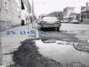
| Description: | Pedestrians walking on the sidewalk along State Highway 21 & 73 in Wautoma. Parked automobiles and parking meters are also visible. |
| Date: | 1967 |
|---|---|
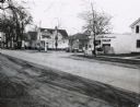
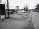
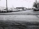
| Description: | A Wautoma, Wisconsin neighborhood. On both sides of the street in both the foreground and middle distance are service stations, beyond them is a residenti... |
| Date: | 1967 |
|---|---|
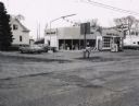
| Description: | A Standard Oil service station located on Oxford Street (State Highway 21&73) in Wautoma, Wisconsin. This photograph relates to the neighborhood view in 3... |
| Date: | 1967 |
|---|---|
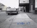
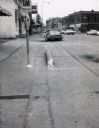
| Description: | Traffic on Oxford Street (State Highway 21&73), with a parking meter in the foreground and old storefronts in the distance. |
| Date: | 1967 |
|---|---|
| Description: | Deep Rock gasoline service station located at the intersection of Scott Street and Oxford Street (STH 21&73) in Wautoma, Wisconsin. |

| Date: | 10 26 1986 |
|---|---|
| Description: | Green Elm Road Bridge over the east fork of Hemlock Creek, showing the rocks used to prevent erosion. |
| Date: | 1967 |
|---|---|
| Description: | Zephyr gasoline station on STH 21&73 in Wautoma, Wisconsin. |
| Date: | 1967 |
|---|---|
| Description: | Mobil Oil service station on the corner of STH 22 and STH 21&73. |

| Date: | 1967 |
|---|---|
| Description: | Sinclair station located on STH 21, 22 & 73 in Wautoma, Wisconsin. |
| Date: | 1967 |
|---|---|
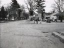
| Description: | Northwestern Street intersection in Wautoma, with the old railroad depot in the background and a parking lot in the foreground. |
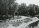
| Date: | 09 20 1972 |
|---|---|
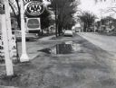
| Description: | Wayside #8 near Necedah in rural Adams County. |
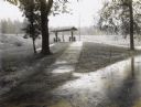
| Date: | 09 30 1970 |
|---|---|
| Description: | Point Bluff Wayside as viewed from the highway bridge above. |

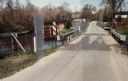
| Date: | 05 02 1985 |
|---|---|
| Description: | Bridge over Duck Creek in the Town of Adams, Adams County, Wisconsin. |
| Date: | 05 02 1985 |
|---|---|
| Description: | Bridge over White Creek in the Town of Easton, Adams County, Wisconsin. |

| Date: | 11 05 1986 |
|---|---|
| Description: | Green Lake County Highway M meandering toward a red barn in the distance on a November day, an archtypal Wisconsin landscape. |
If you didn't find the material you searched for, our Library Reference Staff can help.
Call our reference desk at 608-264-6535 or email us at: