Filter: Categories of Wisconsin Historical Images
Filter: FORMAT_NUMBER_ORG of PH 6445
Filter: Year of 1900-1999
Filter: Subject of transportation
Filter: Subject of persons
Filter: Categories of Wisconsin Historical Images
Filter: FORMAT_NUMBER_ORG of PH 6445
Filter: Year of 1900-1999
Filter: Subject of transportation
Filter: Subject of persons

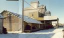
| Date: | 04 30 1971 |
|---|---|
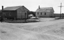
| Description: | The cheese factory owned by Bernard Herndel located on rural State Highway 13 in Marathon County. |
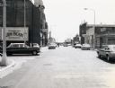
| Date: | 07 28 1970 |
|---|---|
| Description: | Traffic on Stevens Point's Second Street. |
| Date: | 08 03 1973 |
|---|---|
| Description: | View of an Elroy alley from Cedar Street. The deteriorating garage in the foreground is of an unusual design. |
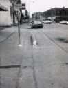
| Date: | 1967 |
|---|---|
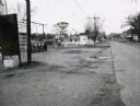
| Description: | Traffic on Oxford Street (State Highway 21&73), with a parking meter in the foreground and old storefronts in the distance. |

| Date: | 10 26 1986 |
|---|---|
| Description: | Green Elm Road Bridge over the east fork of Hemlock Creek, showing the rocks used to prevent erosion. |
| Date: | 1967 |
|---|---|
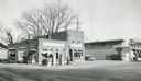
| Description: | Zephyr gasoline station on STH 21&73 in Wautoma, Wisconsin. |
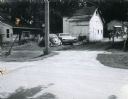
| Date: | 1967 |
|---|---|
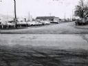
| Description: | Northwestern Street intersection in Wautoma, with the old railroad depot in the background and a parking lot in the foreground. |

| Date: | 11 05 1986 |
|---|---|
| Description: | Green Lake County Highway M meandering toward a red barn in the distance on a November day, an archtypal Wisconsin landscape. |
| Date: | 03 21 1986 |
|---|---|
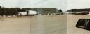
| Description: | Office and metal warehouse of Potato World, Inc., located on County Highway E near Grand Marsh in Adams County. |
| Date: | 1957 |
|---|---|
| Description: | Skelly service station, restaurant, and motel located along STH 12 in Mauston, Wisconsin. |
| Date: | 02 12 1970 |
|---|---|
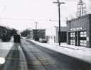
| Description: | State Highway 51 in Iola, Wisconsin, primarily showing the Fire Department and its siren. |
| Date: | 06 01 1966 |
|---|---|
| Description: | Highway County CTH "N" looking southeast. The white building on the right is the Marathon Town Hall. |

| Date: | 11 29 1989 |
|---|---|
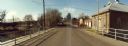
| Description: | Panoramic view of the Union Street Bridge in the village of Rosholt created by taping three images together. |

| Date: | 11 30 1989 |
|---|---|
| Description: | Panoramic view of the bridge over the frozen Eau Claire River. |

| Date: | 11 16 1989 |
|---|---|
| Description: | McNinch Road, an unpaved road near the Little Wolf River crossing in the town of Wyoming. |
| Date: | 11 16 1989 |
|---|---|
| Description: | View from the Water Street Bridge over the Waupaca River toward the Waupaca Water Department. |
If you didn't find the material you searched for, our Library Reference Staff can help.
Call our reference desk at 608-264-6535 or email us at: