 Filter: Categories of Wisconsin Historical Images
Filter: FORMAT_NUMBER_ORG of PH 6445
Filter: Subject of transportation
Filter: Categories of Wisconsin Historical Images
Filter: FORMAT_NUMBER_ORG of PH 6445
Filter: Subject of transportation
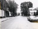
| Date: | 11 12 1967 |
|---|---|
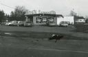
| Description: | Rog's Superette, a small grocery store located on Main Street (STH 13) in Wisconsin Rapids. |
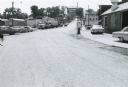
| Date: | 10 10 1972 |
|---|---|
| Description: | Panoramic view of the intersection of CTH Z and STH 13 near Wisconsin Rapids. A billboard to the left advertises the Ridges Inn and Country Club; on the r... |

| Date: | |
|---|---|
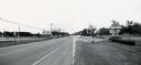
| Description: | Panoramic view of the highway wayside located on State Highway 13 in Wood County near Klondike Corners. |

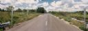
| Date: | |
|---|---|
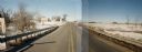
| Description: | Panoramic view of State Highway 13 in Wood County from an unidentified intersecting local road. |

| Date: | 02 05 1975 |
|---|---|
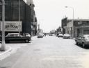
| Description: | Businesses at the intersection of Capron and Water Street downtown. In the foreground is a beer truck making a delivery to the Corner Bar and across the s... |

| Date: | 04 02 1970 |
|---|---|
| Description: | Home office and plant of the Bar-coat Black Top Company on US Highway 51 north of Mosinee. |
| Date: | 07 28 1970 |
|---|---|
| Description: | Traffic on Stevens Point's Second Street. |
| Date: | 07 28 1971 |
|---|---|
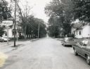
| Description: | Older residences along Second Street in Stevens Point. |
| Date: | 07 28 1971 |
|---|---|
| Description: | The Fourth Street intersection in Stevens Point. |

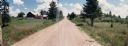
| Date: | 06 29 1968 |
|---|---|
| Description: | View of rural Monroe County Highway P, looking east toward a house in the curve of the road. |
| Date: | 06 29 1968 |
|---|---|
| Description: | Monroe County Highway P in Kendall, Wisconsin, looking south. The view includes an automobile service station and dealership, with automobiles and trucks ... |

| Date: | 1968 |
|---|---|
| Description: | Standard Oil station with road work taking place in the foreground. Included in the view is a telephone booth. |

| Date: | 06 1980 |
|---|---|
| Description: | Identified only as the intersection of Flowage Road and State Highway 173 in Juneau County, this image probably shows the entrance to the Meadow Valley Flo... |

| Date: | |
|---|---|
| Description: | Town Line Road in Wausau, looking west, toward a residential neighborhood. On the left is the Weltman Furniture store which also appears in Image 36020. |
| Date: | 07 20 1988 |
|---|---|
| Description: | Panoramic view from the Big Sandy Creek Bridge, looking north on Marathon County Highway Q. |
| Date: | 07 20 1988 |
|---|---|
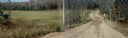
| Description: | Lincoln Drive Bridge in the Town of Berlin, Marathon County. The road in the foreground is not paved, and to the left is a red barn. |

| Date: | 03 16 1984 |
|---|---|
| Description: | A wintertime panoramic view of the bridge on Rainbow Drive, a local road in the Town of Halsey, Marathon County, looking east. |
| Date: | 10 30 1987 |
|---|---|
| Description: | Panoramic view of 28th Avenue winding through the Town of Maine in Marathon County. |
| Date: | 03 03 1988 |
|---|---|
| Description: | View from bridge over Wild Creek on Marathon County Highway M. The creek appears frozen, although in flood. Several farms can be seen in the distance. |
| Date: | |
|---|---|
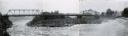
| Description: | Panoramic view of the old Highway 153 bridge over the Wisconsin River at Mosinee. |
If you didn't find the material you searched for, our Library Reference Staff can help.
Call our reference desk at 608-264-6535 or email us at: