 Filter: Categories of Wisconsin Historical Images
Filter: FORMAT_NUMBER_ORG of PH 144
Filter: Subject of intellectual life
Filter: Subject of trees
Filter: Categories of Wisconsin Historical Images
Filter: FORMAT_NUMBER_ORG of PH 144
Filter: Subject of intellectual life
Filter: Subject of trees
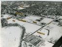
| Date: | 1965 |
|---|---|
| Description: | Aerial view of the UW-Madison campus near University Bay in winter. Labels are pasted to the print to indicate Elm Dr., the gym, Camp Randall Stadium, the ... |

| Date: | |
|---|---|
| Description: | An aerial view of Governor's Island. A cutout of an arrow has been added. |

| Date: | |
|---|---|
| Description: | Aerial view of Vieth's Park subdivision on the north shore of Lake Mendota. |
| Date: | |
|---|---|
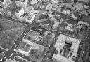
| Description: | Aerial view of Madison, including the Capitol Square on the left at Mifflin and State Street, and Central High School, the light-colored building in the fo... |

| Date: | |
|---|---|
| Description: | Aerial view of the Capitol Square, with Capitol Park and part of the Wisconsin State Capitol. Manchester's is on the corner of Mifflin Street at Wisconsin ... |
| Date: | |
|---|---|
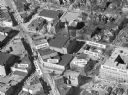
| Description: | Aerial view of Madison, including Yost's, State Street, The Orpheum Theatre, Hills, the Madison Public Library, block 64 parking, East Johnson Street, and ... |

| Date: | |
|---|---|
| Description: | Aerial view of Madison featuring Central High School/Madison Area Technical College (MATC) at top center. |
If you didn't find the material you searched for, our Library Reference Staff can help.
Call our reference desk at 608-264-6535 or email us at: