 Filter: Categories of Wisconsin Historical Images
Filter: FORMAT_DIMENSIONS of unknown
Filter: Year of 1900-1999
Filter: Subject of cities and towns
Filter: Categories of Wisconsin Historical Images
Filter: FORMAT_DIMENSIONS of unknown
Filter: Year of 1900-1999
Filter: Subject of cities and towns

| Date: | 1999 |
|---|---|
| Description: | Exterior view of Waupun City Hall, 201 E. Main Street, built in 1928. |

| Date: | 01 1980 |
|---|---|
| Description: | Exterior view of the Nathan Shapiro House at 3059 South Kinnickinnic Avenue. |

| Date: | 1908 |
|---|---|
| Description: | A Sanborn fire map of Brodhead. Includes an inset at top right showing distances from P.O. |

| Date: | 1908 |
|---|---|
| Description: | A Sanborn map of the isthmus, which includes the map key. |

| Date: | 1908 |
|---|---|
| Description: | A Sanborn map including a portion of the East Johnson Street and East Gorham Street neighborhood. |
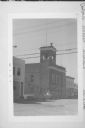
| Date: | 08 1974 |
|---|---|
| Description: | Exterior view of Hustisford City Hall at 210 South Lake Street. There is a siren on top of the building. |
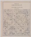
| Date: | 1920 |
|---|---|
| Description: | A plat map of the town of Granville in Milwaukee County, Wisconsin. |
If you didn't find the material you searched for, our Library Reference Staff can help.
Call our reference desk at 608-264-6535 or email us at:


