Filter: Categories of Wisconsin Historical Images
Filter: FORMAT_DIMENSIONS of unknown
Filter: Subject of water
Filter: Categories of Wisconsin Historical Images
Filter: FORMAT_DIMENSIONS of unknown
Filter: Subject of water

| Date: | 1915 |
|---|---|
| Description: | Group of people setting up for a picnic on a beach at Apostle Island. |
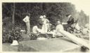
| Date: | |
|---|---|
| Description: | Group of people at a picnic on the shoreline at Bass Island. Names written on back of print: Mrs. Abernathy, chair; Mrs. Hull; Mrs. Baker. |

| Date: | 1915 |
|---|---|
| Description: | This map shows the extent of Wisconsin and pre-Wisconsin drift. The bottom left of the map includes a map categorizing the colors used into geologic period... |

| Date: | 1908 |
|---|---|
| Description: | Sanborn map of Madison, including West Gilman and Langdon Streets. |

| Date: | 1918 |
|---|---|
| Description: | Manuscript map of the Chequamegon Bay area on Lake Superior drawn by Warren W. Witmer and illustrated with sketches by Mary L. Wright Witmer in ink and wat... |

| Date: | 1928 |
|---|---|
| Description: | This map shows a view of the Milwaukee metropolitan area. It highlights state trunk highways, principal county trunks and other secondary highways and type... |

| Date: | 06 2008 |
|---|---|
| Description: | View looking east of a 1000-year-old Indian intaglio effigy in the shape of a panther. The effigy, which is on the north bank of the Rock River, is filled ... |
| Date: | 05 1894 |
|---|---|
| Description: | Sheet 1 of an Onalaska Sanborn map, which includes an index and key. |
| Date: | 05 1894 |
|---|---|
| Description: | Sheet 4 of an Onalaska Sanborn map featuring C.H. Nichols Lumber Company. |
| Date: | 05 1894 |
|---|---|
| Description: | Sheet 5 of an Sanborn map of Onalaska featuring the Island Lumber Company. |

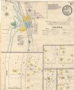
| Date: | 1908 |
|---|---|
| Description: | A Sanborn map featuring the Capitol Square and surrounding business district. |

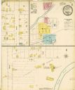
| Date: | 1901 |
|---|---|
| Description: | A Sanborn map of Tomahawk featuring the Bay Mill Company's lumber yard. |

| Date: | 04 1901 |
|---|---|
| Description: | A Sanborn map of Watertown, including an index and a key. |

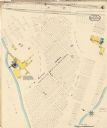
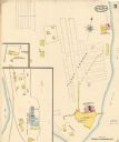
| Date: | 10 1884 |
|---|---|
| Description: | A Sanborn map of Watertown, including the City Brewery and the Rock River. |
If you didn't find the material you searched for, our Library Reference Staff can help.
Call our reference desk at 608-264-6535 or email us at: