 Filter: Categories of Wisconsin Historical Images
Filter: FORMAT_DIMENSIONS of unknown
Filter: Subject of streets
Filter: Community of Milwaukee
Filter: Categories of Wisconsin Historical Images
Filter: FORMAT_DIMENSIONS of unknown
Filter: Subject of streets
Filter: Community of Milwaukee
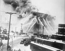
| Date: | 12 11 1926 |
|---|---|
| Description: | Fire destroyed the Atlas Flour Mill, causing an estimated $100,000 in damage. Thirteen engine companies, six truck companies, and two fire boats fought the... |

| Date: | |
|---|---|
| Description: | Stereograph of southwest facade on Martin Street. Built circa 1872. Architect was E.T. Mix. Dirt road in front, and the tower of the Immanuel Church is in... |

| Date: | 1894 |
|---|---|
| Description: | Sanborn map of Milwaukee, with the Milwaukee River on the left, and Water Street in the center. There are two iron draw bridges over the river. |

| Date: | 01 1980 |
|---|---|
| Description: | Exterior view of the Nathan Shapiro House at 3059 South Kinnickinnic Avenue. |
If you didn't find the material you searched for, our Library Reference Staff can help.
Call our reference desk at 608-264-6535 or email us at:

