 Filter: Categories of Wisconsin Historical Images
Filter: FORMAT_DIMENSIONS of unknown
Filter: Subject of rivers
Filter: Subject of lumber trade
Filter: Categories of Wisconsin Historical Images
Filter: FORMAT_DIMENSIONS of unknown
Filter: Subject of rivers
Filter: Subject of lumber trade
| Date: | 1905 |
|---|---|
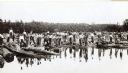
| Description: | Log driving crew for the Chippewa Lumber & Boom Company. Crew members are in the process of breaking a jam at the Big Eddy. One of the men is carrying a yo... |
| Date: | |
|---|---|
| Description: | Stereograph of a man on a raft pulling down on the end of a hand hewn log, most likely the oar, while a second man stands by and watches. |
| Date: | |
|---|---|
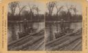
| Description: | Stereograph of a man standing in rowboat at the edge of a raft. There is a rope leading from the raft to the rowboat. |
| Date: | 1886 |
|---|---|
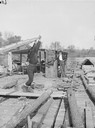
| Description: | Stereograph of men unloading lumber off a raft. A man at the left loads lumber onto a horse-drawn wagon while a man in an apron holds the horses. There is ... |
| Date: | 1886 |
|---|---|
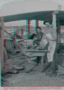
| Description: | Stereograph of Ashley Bennett ("Cookie") who volunteered his services during the float, and the cook Mike Lane, on the Arpin fleet of lumber rafts. |
| Date: | 1886 |
|---|---|
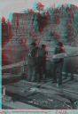
| Description: | Stereograph of four raftsmen shipping an oar in the Dells. |
| Date: | |
|---|---|
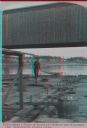
| Description: | Stereograph of a man standing on the back of a raft holding a hand-hewned oar. The raft is passing under a wooden bridge. A town, including a church, are i... |
| Date: | 05 1894 |
|---|---|
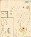
| Description: | Sheet 5 of an Sanborn map of Onalaska featuring the Island Lumber Company. |
If you didn't find the material you searched for, our Library Reference Staff can help.
Call our reference desk at 608-264-6535 or email us at:


