 Filter: Categories of Wisconsin Historical Images
Filter: FORMAT_DIMENSIONS of unknown
Filter: Subject of rivers
Filter: Subject of dwellings
Filter: Categories of Wisconsin Historical Images
Filter: FORMAT_DIMENSIONS of unknown
Filter: Subject of rivers
Filter: Subject of dwellings
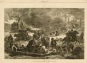
| Date: | 11 25 1871 |
|---|---|
| Description: | Engraved view of Peshtigo Fire showing people trying to escape the flames by boat and on horseback. A team of cattle also seek refuge and several birds tak... |
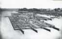
| Date: | 1870 |
|---|---|
| Description: | Elevated view of lumber raft and workers on the Chippewa River. In the background on the right are dwellings. |

| Date: | |
|---|---|
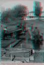
| Description: | A Menominee Indian Village on Wolf River. There are dwellings on the shore and many people in canoes are on the river. |
| Date: | 1886 |
|---|---|
| Description: | Stereograph of men unloading lumber off a raft. A man at the left loads lumber onto a horse-drawn wagon while a man in an apron holds the horses. There is ... |
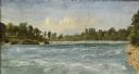
| Date: | 1856 |
|---|---|
| Description: | "....The third view was twelve miles farther up the river [from De Pere], at Rapid Croche, on the border of the present Brown and Outagamie counties. It is... |

| Date: | 1908 |
|---|---|
| Description: | A Sanborn fire map of Brodhead. Includes an inset at top right showing distances from P.O. |
If you didn't find the material you searched for, our Library Reference Staff can help.
Call our reference desk at 608-264-6535 or email us at:


