 Filter: Categories of Wisconsin Historical Images
Filter: FORMAT_DIMENSIONS of unknown
Filter: Subject of neighborhoods
Filter: Community of Madison
Filter: Categories of Wisconsin Historical Images
Filter: FORMAT_DIMENSIONS of unknown
Filter: Subject of neighborhoods
Filter: Community of Madison
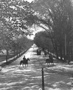
| Date: | 1896 |
|---|---|
| Description: | Tree-lined State Street from Bascom Hill on the University of Wisconsin-Madison campus. Traffic on State Street includes two well-dressed gentlemen on hors... |
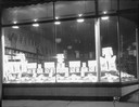
| Date: | 02 10 1935 |
|---|---|
| Description: | Frank Brothers Store, 609 University Avenue, Gold Medal Flour and Bisquick display window. |
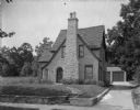
| Date: | 08 25 1927 |
|---|---|
| Description: | House at 454 Virginia Terrace, view from right at driveway. |
| Date: | 11 03 1926 |
|---|---|
| Description: | Exterior view of Phi Pi Phi House, 250 Langdon Street. |
| Date: | 04 1926 |
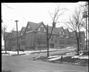
|---|---|
| Description: | View across street towards the Randall Elementary School, 1802 Regent Street at 10 N. Spooner Street. |

| Date: | 03 03 1926 |
|---|---|
| Description: | Orpheum Theater under construction, 216 State Street, looking east. |

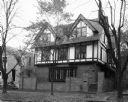
| Date: | 05 26 1926 |
|---|---|
| Description: | Three-quarter view from left towards the Harold K. Meyers house, at 1910 Vilas Avenue. A house is next door on the right. |

| Date: | 05 26 1926 |
|---|---|
| Description: | Three-quarter view from right towards the front of the Harold K. Meyers house, at 1910 Vilas Avenue. A house is next door on the left. |
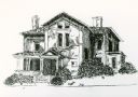
| Date: | 1973 |
|---|---|
| Description: | A depiction of the Breese Stevens house at 401 North Carroll Street. Located in the Mansion Hill neighborhood, the house was built in 1863. |
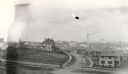
| Date: | |
|---|---|
| Description: | Elevated view of University Heights, looking north from Ely Place towards Bascom Hall. The following houses are visible: Professor Richard T. Ely house, 20... |

| Date: | 1908 |
|---|---|
| Description: | A Sanborn map featuring the Capitol Square and surrounding business district. |

| Date: | |
|---|---|
| Description: | Exterior view of the house at 1240 Sherman Avenue. |

| Date: | 1890 |
|---|---|
| Description: | Plat map of Madison, T7N R9E, including portions of the towns of Blooming Grove and Burke. Includes inset maps of South Madison, Quarrytown, Marril Park, a... |

| Date: | 1908 |
|---|---|
| Description: | A Sanborn map including a portion of the East Johnson Street and East Gorham Street neighborhood. |
If you didn't find the material you searched for, our Library Reference Staff can help.
Call our reference desk at 608-264-6535 or email us at: