Filter: Categories of Wisconsin Historical Images
Filter: FORMAT_DIMENSIONS of unknown
Filter: Subject of michigan, lake
Filter: Categories of Wisconsin Historical Images
Filter: FORMAT_DIMENSIONS of unknown
Filter: Subject of michigan, lake
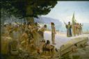
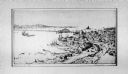
| Date: | 1904 |
|---|---|
| Description: | Jean Nicolet (1598-1642) was the first European to see Wisconsin and was a prominent French explorer who, for many years, lived among the Indians of Quebec... |

| Date: | 1848 |
|---|---|
| Description: | In 1849, northern Wisconsin was composed of huge sectional regions such as Chippewa, Portage, Brown and Crawford, whereas southern Wisconsin was constitute... |

| Date: | 1862 |
|---|---|
| Description: | Drawn the second year of the Civil War, this 1862 map of Milwaukee shows post offices, light houses, beacon lights, county buildings, elevator warehouses, ... |

| Date: | 1838 |
|---|---|
| Description: | Compiled from the latest authorities. Published by Hinman and Dutton. |

| Date: | 1860 |
|---|---|
| Description: | This colored map shows railroad lines east of the Mississippi as well as in the states bordering the Mississippi River. The Great Lakes and Gulf of Mexico ... |

| Date: | 1873 |
|---|---|
| Description: | A hand-colored map of Minnesota, Wisconsin, and Michigan shows the counties, cities, villages, rivers, lakes, railroads, and steamboat routes in these stat... |

| Date: | 1882 |
|---|---|
| Description: | A geological map of northern Wisconsin showing the locations of different soil types in the state such as sandy soil, sandy loam, prairie loam, clayey loam... |

| Date: | 1915 |
|---|---|
| Description: | This map shows the extent of Wisconsin and pre-Wisconsin drift. The bottom left of the map includes a map categorizing the colors used into geologic period... |

| Date: | 1928 |
|---|---|
| Description: | This map shows a view of the Milwaukee metropolitan area. It highlights state trunk highways, principal county trunks and other secondary highways and type... |
If you didn't find the material you searched for, our Library Reference Staff can help.
Call our reference desk at 608-264-6535 or email us at: