 Filter: Categories of Wisconsin Historical Images
Filter: FORMAT_DIMENSIONS of unknown
Filter: Subject of landforms
Filter: Subject of lakes
Filter: Categories of Wisconsin Historical Images
Filter: FORMAT_DIMENSIONS of unknown
Filter: Subject of landforms
Filter: Subject of lakes

| Date: | 06 30 1926 |
|---|---|
| Description: | View across Observatory Drive, looking down towards the Van Hise dormitories: Adams, Tripp, and Carson Gulley Commons. Picnic Point is in the distance on L... |
| Date: | |
|---|---|
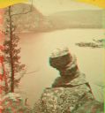
| Description: | Stereograph over Devil's Lake with Turk's Head rock formation in the foreground. |

| Date: | |
|---|---|
| Description: | Detail from a drawing of a plan for the isthmus. |

| Date: | 1890 |
|---|---|
| Description: | Plat map of Madison, T7N R9E, including portions of the towns of Blooming Grove and Burke. Includes inset maps of South Madison, Quarrytown, Marril Park, a... |

| Date: | 1908 |
|---|---|
| Description: | A Sanborn map of the isthmus, which includes the map key. |
If you didn't find the material you searched for, our Library Reference Staff can help.
Call our reference desk at 608-264-6535 or email us at: