Filter: Categories of Wisconsin Historical Images
Filter: FORMAT_DIMENSIONS of unknown
Filter: Subject of land
Filter: Categories of Wisconsin Historical Images
Filter: FORMAT_DIMENSIONS of unknown
Filter: Subject of land

| Date: | 1998 |
|---|---|
| Description: | This scene was painted by Seferina Contreras Klinger from memories of her grandmother, Aurelia M. Contreras, and her uncle, Fidel Contreras, who worked pic... |

| Date: | 1959 |
|---|---|
| Description: | This map shows wards and precincts by number, local streets, roads, parks, Shorewood Hills, Maple Bluff, Middleton, Verona, McFarland, Monona, Truax Field,... |
| Date: | 1913 |
|---|---|
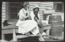
| Description: | Two girls and a girl sit on the wooden stoop near a door. Grant's Point farm, Madeline Island. |

| Date: | 1915 |
|---|---|
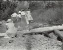
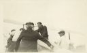
| Description: | View looking towards shoreline of three men and one woman setting up a fire on the rocks for a picnic. There is a picnic basket on the log on the right, an... |
| Date: | 1915 |
|---|---|
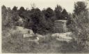
| Description: | Quarry at Hermit Island (Wilson Island). Stones, plants and a foundation are in the foreground. In the background among trees is a wooden structure. |
| Date: | |
|---|---|
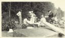
| Description: | Group of people at a picnic on the shoreline at Bass Island. Names written on back of print: Mrs. Abernathy, chair; Mrs. Hull; Mrs. Baker. |
| Date: | 1910 |
|---|---|
| Description: | Group of people standing in front of Cedar Bark Lodge on (Wilson) Hermit Island, Apostle Islands. Cedar Bark Lodge was also known as the Hermitage. |
| Date: | 1918 |
|---|---|
| Description: | Men gathered around airplane. Clarence Russell? on right side. |
| Date: | 1915 |
|---|---|
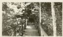
| Description: | Wooden walkway with railings surrounded by trees. |

| Date: | 1915 |
|---|---|
| Description: | This map shows the extent of Wisconsin and pre-Wisconsin drift. The bottom left of the map includes a map categorizing the colors used into geologic period... |

| Date: | 1901 |
|---|---|
| Description: | A Sanborn map of Tomahawk featuring the Bay Mill Company's lumber yard. |

| Date: | 1890 |
|---|---|
| Description: | Plat map of Madison, T7N R9E, including portions of the towns of Blooming Grove and Burke. Includes inset maps of South Madison, Quarrytown, Marril Park, a... |

| Date: | 1908 |
|---|---|
| Description: | A Sanborn map of the isthmus, which includes the map key. |
| Date: | 1896 |
|---|---|
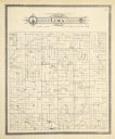
| Description: | A plat map of the township of Lima in Pepin County. |

| Date: | 1899 |
|---|---|
| Description: | A plat map of Pleasant Springs in Dane County. |
If you didn't find the material you searched for, our Library Reference Staff can help.
Call our reference desk at 608-264-6535 or email us at: