Filter: Categories of Wisconsin Historical Images
Filter: FORMAT_DIMENSIONS of unknown
Filter: Subject of lakes
Filter: Subject of transportation
Filter: Categories of Wisconsin Historical Images
Filter: FORMAT_DIMENSIONS of unknown
Filter: Subject of lakes
Filter: Subject of transportation

| Date: | 1956 |
|---|---|
| Description: | Dwight D. Eisenhower and his brothers on a fishing trip proudly exhibiting muskies and northern pike on a Wisconsin lake. From left are Dwight, Edgar, Milt... |

| Date: | 1950 |
|---|---|
| Description: | Gypsy Rose Lee (aka Louise Hovick, 1914-1970) with a large muskie she caught in a northern Wisconsin lake. |

| Date: | |
|---|---|
| Description: | The Eben Peck cabin was the first house built in Madison. |

| Date: | 1836 |
|---|---|
| Description: | The top map is the "Plat of Madison the Capitol of Wisconsin." The bottom map is the "Map of the Four Lake Country. Taken from the Township Maps in the U.S... |

| Date: | 06 30 1926 |
|---|---|
| Description: | View across Observatory Drive, looking down towards the Van Hise dormitories: Adams, Tripp, and Carson Gulley Commons. Picnic Point is in the distance on L... |

| Date: | 1837 |
|---|---|
| Description: | Photographic print of an amateur painting, probably representing the "first house in Madison, Wisconsin." The Peck Cabin, one of the many free variations o... |
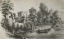
| Date: | 1863 |
|---|---|
| Description: | View of the shoreline on the Walker Castle grounds. Two men are boating while a young boy fishes from the shore. |

| Date: | 1913 |
|---|---|
| Description: | A wall atlas of Sauk County, Wisconsin, displaying its 22 towns. On the left side are advertisements for local businesses. |
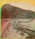
| Date: | 1874 |
|---|---|
| Description: | A yellow mount stereograph of the railroad tracks skirting the edge of Devil's Lake, with several boats tied up alongside. From the stereograph series "The... |

| Date: | 1873 |
|---|---|
| Description: | A hand-colored map of Minnesota, Wisconsin, and Michigan shows the counties, cities, villages, rivers, lakes, railroads, and steamboat routes in these stat... |

| Date: | 11 14 1942 |
|---|---|
| Description: | This pictorial map illustrates Potawatomi Indian legends from the region of Lower Phantom Lake, labeled Howitt Lake on the map, Phantom Lake, and Mukwonag... |

| Date: | 1982 |
|---|---|
| Description: | Color map. "Topography by photogrammetric methods from aerial photographs taken 1963. Revised from aerial photographs taken 1978. Field checked 1979. Map e... |

| Date: | |
|---|---|
| Description: | Detail from a drawing of a plan for the isthmus. |

| Date: | 1908 |
|---|---|
| Description: | Sanborn map of Madison, including West Gilman and Langdon Streets. |

| Date: | 1918 |
|---|---|
| Description: | Manuscript map of the Chequamegon Bay area on Lake Superior drawn by Warren W. Witmer and illustrated with sketches by Mary L. Wright Witmer in ink and wat... |

| Date: | 1908 |
|---|---|
| Description: | A Sanborn map featuring the Capitol Square and surrounding business district. |

| Date: | 1890 |
|---|---|
| Description: | Plat map of Madison, T7N R9E, including portions of the towns of Blooming Grove and Burke. Includes inset maps of South Madison, Quarrytown, Marril Park, a... |

| Date: | 1908 |
|---|---|
| Description: | A Sanborn map of the isthmus, which includes the map key. |
If you didn't find the material you searched for, our Library Reference Staff can help.
Call our reference desk at 608-264-6535 or email us at: