Filter: Categories of Wisconsin Historical Images
Filter: FORMAT_DIMENSIONS of unknown
Filter: Subject of lakes
Filter: Subject of land
Filter: Categories of Wisconsin Historical Images
Filter: FORMAT_DIMENSIONS of unknown
Filter: Subject of lakes
Filter: Subject of land

| Date: | |
|---|---|
| Description: | The Eben Peck cabin was the first house built in Madison. |

| Date: | 1848 |
|---|---|
| Description: | In 1849, northern Wisconsin was composed of huge sectional regions such as Chippewa, Portage, Brown and Crawford, whereas southern Wisconsin was constitute... |

| Date: | 1861 |
|---|---|
| Description: | Drawn the first year of the Civil War, this colored 1861 map of Dane County shows its towns, cities and lakes. It includes insets of the wards of Madison a... |

| Date: | 1836 |
|---|---|
| Description: | The top map is the "Plat of Madison the Capitol of Wisconsin." The bottom map is the "Map of the Four Lake Country. Taken from the Township Maps in the U.S... |
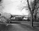
| Date: | 11 20 1926 |
|---|---|
| Description: | View from Observatory Hill of the new Men's Lakeshore dormitories at the University of Wisconsin-Madison, showing Chamberlin Rock in the foreground. The do... |

| Date: | 06 30 1926 |
|---|---|
| Description: | View across Observatory Drive, looking down towards the Van Hise dormitories: Adams, Tripp, and Carson Gulley Commons. Picnic Point is in the distance on L... |
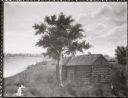
| Date: | |
|---|---|
| Description: | Photographic print of an amateur painting of the Peck Cabin representing the "first house in Madison, Wisconsin." The "Peck Cabin" is a variation signed "M... |

| Date: | 1837 |
|---|---|
| Description: | Photographic print of an amateur painting, probably representing the "first house in Madison, Wisconsin." The Peck Cabin, one of the many free variations o... |
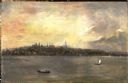
| Date: | 1863 |
|---|---|
| Description: | View of the shoreline on the Walker Castle grounds. Two men are boating while a young boy fishes from the shore. |

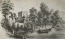
| Date: | 1913 |
|---|---|
| Description: | A wall atlas of Sauk County, Wisconsin, displaying its 22 towns. On the left side are advertisements for local businesses. |
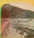
| Date: | 1874 |
|---|---|
| Description: | A yellow mount stereograph of the railroad tracks skirting the edge of Devil's Lake, with several boats tied up alongside. From the stereograph series "The... |
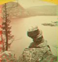
| Date: | |
|---|---|
| Description: | Stereograph over Devil's Lake with Turk's Head rock formation in the foreground. |

| Date: | 1982 |
|---|---|
| Description: | Color map. "Topography by photogrammetric methods from aerial photographs taken 1963. Revised from aerial photographs taken 1978. Field checked 1979. Map e... |

| Date: | |
|---|---|
| Description: | Detail from a drawing of a plan for the isthmus. |

| Date: | 1890 |
|---|---|
| Description: | Plat map of Madison, T7N R9E, including portions of the towns of Blooming Grove and Burke. Includes inset maps of South Madison, Quarrytown, Marril Park, a... |

| Date: | 1908 |
|---|---|
| Description: | A Sanborn map of the isthmus, which includes the map key. |

| Date: | 1899 |
|---|---|
| Description: | A plat map of Pleasant Springs in Dane County. |
If you didn't find the material you searched for, our Library Reference Staff can help.
Call our reference desk at 608-264-6535 or email us at: