 Filter: Categories of Wisconsin Historical Images
Filter: FORMAT_DIMENSIONS of unknown
Filter: Subject of industries
Filter: Categories of Wisconsin Historical Images
Filter: FORMAT_DIMENSIONS of unknown
Filter: Subject of industries

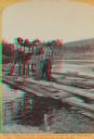
| Date: | 1886 |
|---|---|
| Description: | Stereograph of several men working at dusk, knee deep in water attending to the raft. |
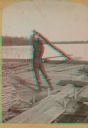
| Date: | 1886 |
|---|---|
| Description: | Stereograph of photographer Henry Hamilton Bennett pulling an oar on a Wisconsin raft. |
| Date: | 1886 |
|---|---|
| Description: | Stereograph of five men standing on a log while another man chops at the log with an axe. |
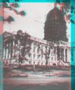
| Date: | |
|---|---|
| Description: | Stereograph view of construction of the Wisconsin State Capitol dome during the construction of the fourth capitol building. The image features the Capitol... |
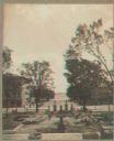
| Date: | 1900 |
|---|---|
| Description: | Stereograph view toward Lake Monona from the State Capitol during the construction of the fourth capitol building. The image features the Capitol Square si... |

| Date: | 1874 |
|---|---|
| Description: | Stereograph of elevated view looking northwest from Exposition Building. There is a church on a street corner on the left, and the Best Brewing Company in ... |

| Date: | |
|---|---|
| Description: | Three men are posing in a stand of pines. On the left two men are standing and holding axes, and on the right is a man posing sitting in a wagon loaded wit... |
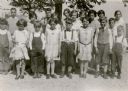
| Date: | 1931 |
|---|---|
| Description: | The students of the Rhine Center School, District No. 6, pose for their photograph in the schoolyard. The girls are wearing good dresses; the boys wear kni... |
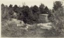
| Date: | 1915 |
|---|---|
| Description: | Quarry at Hermit Island (Wilson Island). Stones, plants and a foundation are in the foreground. In the background among trees is a wooden structure. |

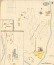
| Date: | 12 1912 |
|---|---|
| Description: | Sanborn Map of Sun Prairie. The map highlights the public and parochial schools, the exhange, and church buildings, etc. |

| Date: | |
|---|---|
| Description: | View over parked cars towards the Superior Refinery, which did business as Murphy Oil Corporation at another time. The oil refinery was located at Stinson ... |

| Date: | |
|---|---|
| Description: | View across field towards the Superior Refinery, which operated under the name Murphy Oil Corporation at another time. |
| Date: | 05 1894 |
|---|---|
| Description: | Sheet 5 of an Sanborn map of Onalaska featuring the Island Lumber Company. |

| Date: | 1901 |
|---|---|
| Description: | A Sanborn map of Tomahawk featuring the Bay Mill Company's lumber yard. |
If you didn't find the material you searched for, our Library Reference Staff can help.
Call our reference desk at 608-264-6535 or email us at:


