Filter: Categories of Wisconsin Historical Images
Filter: FORMAT_DIMENSIONS of unknown
Filter: Subject of human settlements
Filter: Subject of railroads
Filter: Categories of Wisconsin Historical Images
Filter: FORMAT_DIMENSIONS of unknown
Filter: Subject of human settlements
Filter: Subject of railroads

| Date: | 1889 |
|---|---|
| Description: | Chicago, Milwaukee & St. Paul passenger depot with several people standing in front of the building. This is the Franklin Street station on East Wilson Str... |

| Date: | 1889 |
|---|---|
| Description: | Original Chicago & North Western Railroad passenger station, 219 South Blair Street at East Wilson Street, with a few men gathered out front. Torn down in... |
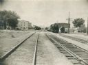
| Date: | 1955 |
|---|---|
| Description: | Chicago and North Western Railroad (CN&W) tracks between Brearly and Ingersoll Streets. |

| Date: | 1913 |
|---|---|
| Description: | A wall atlas of Sauk County, Wisconsin, displaying its 22 towns. On the left side are advertisements for local businesses. |

| Date: | |
|---|---|
| Description: | This detailed map shows fortifications, headquarters, location and dates of battles, street outline of Atlanta, roads, railroads, vegetation, drainage, rel... |

| Date: | 1862 |
|---|---|
| Description: | This detailed map shows batteries and rifle pits, railroads, common and military roads, turnpikes, city streets and names, bridges, ferries, rural houses a... |

| Date: | 1873 |
|---|---|
| Description: | A hand-colored map of Minnesota, Wisconsin, and Michigan shows the counties, cities, villages, rivers, lakes, railroads, and steamboat routes in these stat... |

| Date: | 1982 |
|---|---|
| Description: | Color map. "Topography by photogrammetric methods from aerial photographs taken 1963. Revised from aerial photographs taken 1978. Field checked 1979. Map e... |

| Date: | 05 1854 |
|---|---|
| Description: | This yellow and black wood block print broadside ties England and France's declaration of war against Russia during the Crimean War into a war against high... |

| Date: | 1959 |
|---|---|
| Description: | This map shows wards and precincts by number, local streets, roads, parks, Shorewood Hills, Maple Bluff, Middleton, Verona, McFarland, Monona, Truax Field,... |

| Date: | 12 1912 |
|---|---|
| Description: | Sanborn map of Sun Prairie, which includes an index and information about water facilities and the fire department. Includes a small inset map of the State... |
If you didn't find the material you searched for, our Library Reference Staff can help.
Call our reference desk at 608-264-6535 or email us at: