Filter: Categories of Wisconsin Historical Images
Filter: FORMAT_DIMENSIONS of unknown
Filter: Subject of human settlements
Filter: Subject of bridges
Filter: Categories of Wisconsin Historical Images
Filter: FORMAT_DIMENSIONS of unknown
Filter: Subject of human settlements
Filter: Subject of bridges
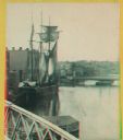
| Date: | |
|---|---|
| Description: | Stereograph of a man standing on the back of a raft holding a hand-hewned oar. The raft is passing under a wooden bridge. A town, including a church, are i... |
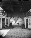
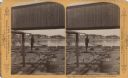
| Date: | 1877 |
|---|---|
| Description: | View towards men and women sitting and standing, beneath the lower deck of a suspension bridge (train uses upper deck). There are two booths (for tolls or ... |

| Date: | 11 17 2004 |
|---|---|
| Description: | Opening day for the new bridge named "Cameron Avenue Bridge." |

| Date: | |
|---|---|
| Description: | Stereograph of a man standing on the back of a raft holding a hand-hewned oar. The raft is passing under a wooden bridge. A town, including a church, are i... |
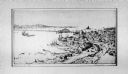
| Date: | 1880 |
|---|---|
| Description: | Stereograph. Part of a bridge is visible in the lower left corner. Under the bridge is a floating pier with advertisements painted on its sides. Another br... |

| Date: | 1875 |
|---|---|
| Description: | Stereograph of Wisconsin Street seen from Spring Street. The building on the left nearest the bridge was the Chicago, Milwaukee & St. Paul Railway's downto... |
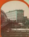
| Date: | 1869 |
|---|---|
| Description: | Stereograph of the Axtell House building, with a storefront next to it advertising "Clothing Hats Caps Sailors Outfits". A bridge is on the left and a man... |

| Date: | 1870 |
|---|---|
| Description: | Stereograph of Main Street bridge, looking toward a section of the city known locally as Brooklyn. |

| Date: | 1862 |
|---|---|
| Description: | This detailed map shows batteries and rifle pits, railroads, common and military roads, turnpikes, city streets and names, bridges, ferries, rural houses a... |

| Date: | 05 01 1899 |
|---|---|
| Description: | Map showing the Schuylkill River with roads, ferries, and points of interest from Valley Forge to Philadelphia, Pennsylvania as it appeared during the Revo... |

| Date: | 1894 |
|---|---|
| Description: | Sanborn map of Milwaukee, with the Milwaukee River on the left, and Water Street in the center. There are two iron draw bridges over the river. |
If you didn't find the material you searched for, our Library Reference Staff can help.
Call our reference desk at 608-264-6535 or email us at: