 Filter: Categories of Wisconsin Historical Images
Filter: FORMAT_DIMENSIONS of unknown
Filter: Subject of hotels
Filter: Categories of Wisconsin Historical Images
Filter: FORMAT_DIMENSIONS of unknown
Filter: Subject of hotels
| Date: | 1883 |
|---|---|
| Description: | Tonyawatha Spring Hotel from a descriptive brochure. The hotel opened in 1879 and was destroyed by fire on July 31, 1895. |
| Date: | 1977 |
|---|---|
| Description: | A view from the west of the Fess Hotel, 123 East Doty Street. |
| Date: | 1839 |
|---|---|
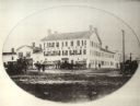
| Description: | Exterior view of the Racine House with multiple horse-drawn wagons and figures standing in front. |
| Date: | 1990 |
|---|---|
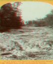
| Description: | Stereograph of a turbulent portion of the Wisconsin River known as the Wicked Water, up through the Narrows. The roof of the Larks Hotel, with the hotel's ... |
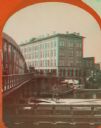
| Date: | 1869 |
|---|---|
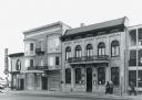
| Description: | Stereograph of the Axtell House building, with a storefront next to it advertising "Clothing Hats Caps Sailors Outfits". A bridge is on the left and a man... |

| Date: | 1860 |
|---|---|
| Description: | Stereograph of the Townsend House boathouse across a lake. |
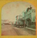
| Date: | 1871 |
|---|---|
| Description: | A stereograph of the town square and Main Street. The three-story building visible in the center of the photograph was operated as the National Hotel. It w... |

| Date: | 05 1854 |
|---|---|
| Description: | This yellow and black wood block print broadside ties England and France's declaration of war against Russia during the Crimean War into a war against high... |

| Date: | 04 1901 |
|---|---|
| Description: | A Sanborn map of Watertown, including an index and a key. |

| Date: | 1877 |
|---|---|
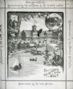
| Description: | A page from an illustrated historical atlas showing four residences, a hotel and the flouring mill of John Ochsner. |
If you didn't find the material you searched for, our Library Reference Staff can help.
Call our reference desk at 608-264-6535 or email us at:


