 Filter: Categories of Wisconsin Historical Images
Filter: FORMAT_DIMENSIONS of unknown
Filter: Subject of food industry and trade
Filter: Categories of Wisconsin Historical Images
Filter: FORMAT_DIMENSIONS of unknown
Filter: Subject of food industry and trade
| Date: | 1948 |
|---|---|
| Description: | Center panel of the completed mural at the Wisconsin Historical Society. The image depicts wheat farming, one of the state's earliest and largest industrie... |

| Date: | 08 17 1957 |
|---|---|
| Description: | Fourteen-year-old Dorothy Magarich proudly displays her pie that won a blue ribbon at the Wisconsin State Fair. |
| Date: | 2009 |
|---|---|
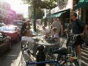
| Description: | Customers around outside seating at Jule's Coffee shop on Pearl Street. |

| Date: | 2008 |
|---|---|
| Description: | David A. Marcou, father of the photographer, and meat-cutter, stands underneath a sign in a store. |
| Date: | 2007 |
|---|---|
| Description: | An exterior view from across street of Bodega Brew Pub on corner of Pearl Street. |
| Date: | 2006 |
|---|---|
| Description: | View from across street of "Buzzard Billy's." There is a decorative fish on top of the establishment. |

| Date: | 10 2007 |
|---|---|
| Description: | Two women (Frauleins) in costume posing for a picture at Oktoberfest. |
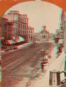
| Date: | 1870 |
|---|---|
| Description: | Stereograph; view of the earlier City Hall building, on Market Square at the corner of E. Water Street and Oneida Street. Several signs are in the image, i... |

| Date: | 1874 |
|---|---|
| Description: | Stereograph of elevated view looking northwest from Exposition Building. There is a church on a street corner on the left, and the Best Brewing Company in ... |
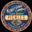
| Date: | |
|---|---|
| Description: | "Cass Brand" Pickles label featuring a badger holding a pickle in the middle of a cabbage patch. Klindt-Geiger Canning Co., located in Cassville, Wisconsin... |
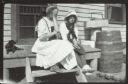
| Date: | 1913 |
|---|---|
| Description: | Two girls and a girl sit on the wooden stoop near a door. Grant's Point farm, Madeline Island. |

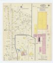
| Date: | 12 1912 |
|---|---|
| Description: | Sanborn Map of Sun Prairie. The map highlights the public and parochial schools, the exhange, and church buildings, etc. |

| Date: | |
|---|---|
| Description: | Exterior view of the Mt. Horeb Co-op Creamery at 102 South Second Street, which was operated by the Ryser Brothers. This view shows a Bavarian-style front,... |
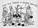
| Date: | |
|---|---|
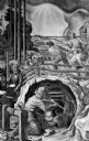
| Description: | Drawing of two men outdoors making moonshine. Two men standing together on the left are dressed in suits, and one of them is carrying a briefcase. The text... |
| Date: | 1915 |
|---|---|
| Description: | A Sanborn map of a portion of Janesville, including the Rock River Sugar Company. |

| Date: | 04 1901 |
|---|---|
| Description: | A Sanborn map of Watertown, including an index and a key. |

| Date: | 10 1884 |
|---|---|
| Description: | A Sanborn map of Watertown, including the City Brewery and the Rock River. |
| Date: | |
|---|---|
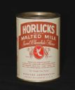
| Description: | A front view of a can of Horlicks Malted Milk in "Sweet Chocolate Flavor." The can has a red trademark and lists the malted milk ingredients. |
| Date: | |
|---|---|
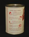
| Description: | A view of the back of a can of Horlicks Malted Milk. The slogan: "Always Fun To Drink" is at the top, and below are reasons one should drink malted milk. |
If you didn't find the material you searched for, our Library Reference Staff can help.
Call our reference desk at 608-264-6535 or email us at:
