 Filter: Categories of Wisconsin Historical Images
Filter: FORMAT_DIMENSIONS of unknown
Filter: Subject of food industry and trade
Filter: Subject of streets
Filter: Categories of Wisconsin Historical Images
Filter: FORMAT_DIMENSIONS of unknown
Filter: Subject of food industry and trade
Filter: Subject of streets
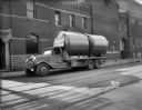
| Date: | 04 17 1934 |
|---|---|
| Description: | View across street towards two new tanks being delivered by the Heil Co. of Milwaukee on a Heil Company truck. The truck is parked in front of the Fauerbac... |
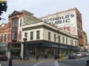
| Date: | 2007 |
|---|---|
| Description: | An exterior view from across street of Bodega Brew Pub on corner of Pearl Street. |
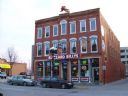
| Date: | 2006 |
|---|---|
| Description: | View from across street of "Buzzard Billy's." There is a decorative fish on top of the establishment. |

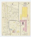
| Date: | 12 1912 |
|---|---|
| Description: | Sanborn Map of Sun Prairie. The map highlights the public and parochial schools, the exhange, and church buildings, etc. |

| Date: | |
|---|---|
| Description: | Exterior view of the Mt. Horeb Co-op Creamery at 102 South Second Street, which was operated by the Ryser Brothers. This view shows a Bavarian-style front,... |
| Date: | 1915 |
|---|---|
| Description: | A Sanborn map of a portion of Janesville, including the Rock River Sugar Company. |

| Date: | 04 1901 |
|---|---|
| Description: | A Sanborn map of Watertown, including an index and a key. |

| Date: | 10 1884 |
|---|---|
| Description: | A Sanborn map of Watertown, including the City Brewery and the Rock River. |

| Date: | 1884 |
|---|---|
| Description: | Page one of a Sanborn map of River Falls, Wisconsin. |

| Date: | |
|---|---|
| Description: | Exterior view from street of the Winz Brewery at 101-105 Manitowoc Street. |
If you didn't find the material you searched for, our Library Reference Staff can help.
Call our reference desk at 608-264-6535 or email us at:


