 Filter: Categories of Wisconsin Historical Images
Filter: FORMAT_DIMENSIONS of unknown
Filter: Subject of economics
Filter: Subject of human settlements
Filter: Categories of Wisconsin Historical Images
Filter: FORMAT_DIMENSIONS of unknown
Filter: Subject of economics
Filter: Subject of human settlements
| Date: | 05 12 1937 |
|---|---|
| Description: | Front door of Lewis D-X Service Station at night, 118 King Street. Sign on door reads: "We meet the finest people in the world at this station --- our cust... |
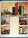
| Date: | 1947 |
|---|---|
| Description: | Advertising poster linking the new International Harvester logo with the company's truck, agricultural equipment, construction equipment, and household ref... |
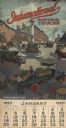
| Date: | 1920 |
|---|---|
| Description: | Calendar advertising "International Motor Trucks." Features a color illustration of men unloading crates of produce from the back of a truck in a city squa... |

| Date: | 2009 |
|---|---|
| Description: | View of Stoughton Opera House stage, advertising curtain and boxes from front of auditorium. |

| Date: | 2009 |
|---|---|
| Description: | Close-up of replica chandelier in Stoughton Opera House. |

| Date: | 1913 |
|---|---|
| Description: | A wall atlas of Sauk County, Wisconsin, displaying its 22 towns. On the left side are advertisements for local businesses. |
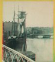
| Date: | 1880 |
|---|---|
| Description: | Stereograph. Part of a bridge is visible in the lower left corner. Under the bridge is a floating pier with advertisements painted on its sides. Another br... |
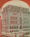
| Date: | 1870 |
|---|---|
| Description: | Stereograph; view of store and adjoining buildings, Wisconsin and Milwaukee Streets. A large statue of a bird sits atop the store in the right of the image... |
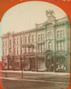
| Date: | 1890 |
|---|---|
| Description: | Stereograph; corner of Broad and Wisconsin Avenues. Built in 1870. E.T. Mix, architect. Victorian details decorate the six story building. A small pile of... |

| Date: | 05 1854 |
|---|---|
| Description: | This yellow and black wood block print broadside ties England and France's declaration of war against Russia during the Crimean War into a war against high... |
If you didn't find the material you searched for, our Library Reference Staff can help.
Call our reference desk at 608-264-6535 or email us at:


