Visit our other Wisconsin Historical Society websites!
 Filter: Categories of Wisconsin Historical Images
Filter: FORMAT_DIMENSIONS of unknown
Filter: Subject of dwellings
Filter: Categories of Wisconsin Historical Images
Filter: FORMAT_DIMENSIONS of unknown
Filter: Subject of dwellings
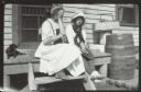
| Date: | 1913 |
|---|---|
| Description: | Two girls and a girl sit on the wooden stoop near a door. Grant's Point farm, Madeline Island. |
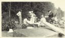
| Date: | |
|---|---|
| Description: | Group of people at a picnic on the shoreline at Bass Island. Names written on back of print: Mrs. Abernathy, chair; Mrs. Hull; Mrs. Baker. |
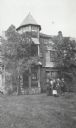
| Date: | 1910 |
|---|---|
| Description: | Group of people standing in front of Cedar Bark Lodge on (Wilson) Hermit Island, Apostle Islands. Cedar Bark Lodge was also known as the Hermitage. |

| Date: | |
|---|---|
| Description: | Exterior view of the Jackson County Home. Flags are hanging from the front porch, which has a balcony above. Men are sitting on the side landing on the lef... |

| Date: | 12 1912 |
|---|---|
| Description: | Sanborn map of Sun Prairie, which includes an index and information about water facilities and the fire department. Includes a small inset map of the State... |

| Date: | 12 1912 |
|---|---|
| Description: | Sanborn map of Sun Prairie, showing Main, Center and Church Streets. |

| Date: | 12 1912 |
|---|---|
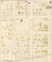
| Description: | Sanborn Map of Sun Prairie. The map highlights the public and parochial schools, the exhange, and church buildings, etc. |
| Date: | |
|---|---|
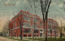
| Description: | The high school, a four-story red brick building. Caption reads: "New High School, Fond du Lac, Wis." |
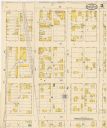
| Date: | 05 1894 |
|---|---|
| Description: | Sheet 2 of an Onalaska Sanborn map, including 2nd, 3rd, and 4th Streets. |

| Date: | 1901 |
|---|---|
| Description: | A Sanborn map of Tomahawk featuring the Bay Mill Company's lumber yard. |

| Date: | |
|---|---|
| Description: | Exterior view of the house at 1240 Sherman Avenue. |

| Date: | |
|---|---|
| Description: | Exterior view of the Chamber of Commerce on the corner of Oak and Broadway. |

| Date: | |
|---|---|
| Description: | The Chamber of Commerce on the corner of Oak and Broadway under a dark sky. |
If you didn't find the material you searched for, our Library Reference Staff can help.
Call our reference desk at 608-264-6535 or email us at: