Filter: Categories of Wisconsin Historical Images
Filter: FORMAT_DIMENSIONS of unknown
Filter: Subject of commercial buildings
Filter: Subject of streets
Filter: Categories of Wisconsin Historical Images
Filter: FORMAT_DIMENSIONS of unknown
Filter: Subject of commercial buildings
Filter: Subject of streets

| Date: | 08 17 1937 |
|---|---|
| Description: | View across street towards a semi-trailer truck delivering 200 new 1937 Super Speed L.C. Smith typewriters. A young boy and three men are standing in the s... |
| Date: | 03 31 1917 |
|---|---|
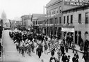
| Description: | Elevated view of men carrying flags marching down State Street from the Wisconsin State Capitol in a Loyalty Day Parade. |
| Date: | 1959 |
|---|---|
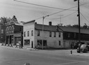
| Description: | View of Main Street, lined with the fire department, city clerk's office, and Pugh's Battery - Electric Shop. |

| Date: | 1912 |
|---|---|
| Description: | Elevated panoramic view of buildings in Stanley. |
| Date: | 2009 |
|---|---|
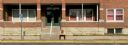
| Description: | Panoramic view from across street of building near bus stop. A man is waiting for the bus near the steps to the building. |
| Date: | 1885 |
|---|---|
| Description: | Main Street in Bayfield in 1870 with four cows standing in the street. |

| Date: | 1894 |
|---|---|
| Description: | Sanborn map of Milwaukee, with the Milwaukee River on the left, and Water Street in the center. There are two iron draw bridges over the river. |

| Date: | 12 1912 |
|---|---|
| Description: | Sanborn map of Sun Prairie, showing Main, Center and Church Streets. |

| Date: | |
|---|---|
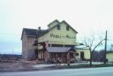
| Description: | Exterior view of the Mt. Horeb Co-op Creamery at 102 South Second Street, which was operated by the Ryser Brothers. This view shows a Bavarian-style front,... |

| Date: | |
|---|---|
| Description: | Exterior view from street of the Winz Brewery at 101-105 Manitowoc Street. |
If you didn't find the material you searched for, our Library Reference Staff can help.
Call our reference desk at 608-264-6535 or email us at: