Filter: Categories of Wisconsin Historical Images
Filter: FORMAT_DIMENSIONS of unknown
Filter: Subject of cities and towns
Filter: Categories of Wisconsin Historical Images
Filter: FORMAT_DIMENSIONS of unknown
Filter: Subject of cities and towns
| Date: | |
|---|---|
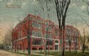
| Description: | The high school, a four-story red brick building. Caption reads: "New High School, Fond du Lac, Wis." |
| Date: | 1975 |
|---|---|
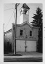
| Description: | View across street towards the Waubeka firehouse at 401 Center Street. In a tower above the entrance is the Red Arrow siren, which has since been removed. |
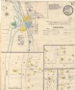
| Date: | 05 1894 |
|---|---|
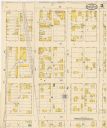
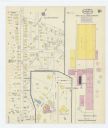
| Description: | Sheet 1 of an Onalaska Sanborn map, which includes an index and key. |
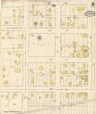
| Date: | 05 1894 |
|---|---|
| Description: | Sheet 2 of an Onalaska Sanborn map, including 2nd, 3rd, and 4th Streets. |
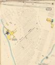
| Date: | 05 1894 |
|---|---|
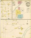
| Description: | Sheet 4 of an Onalaska Sanborn map featuring C.H. Nichols Lumber Company. |
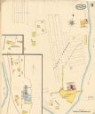
| Date: | 05 1894 |
|---|---|
| Description: | Sheet 5 of an Sanborn map of Onalaska featuring the Island Lumber Company. |
| Date: | 1915 |
|---|---|
| Description: | A Sanborn map of a portion of Janesville, including the Rock River Sugar Company. |

| Date: | 1908 |
|---|---|
| Description: | A Sanborn map featuring the Capitol Square and surrounding business district. |

| Date: | 1901 |
|---|---|
| Description: | A Sanborn map of Tomahawk featuring the Bay Mill Company's lumber yard. |

| Date: | |
|---|---|
| Description: | Exterior view of the Chamber of Commerce on the corner of Oak and Broadway. |

| Date: | |
|---|---|
| Description: | The Chamber of Commerce on the corner of Oak and Broadway under a dark sky. |

| Date: | |
|---|---|
| Description: | Four men taking part in a ribbon-cutting ceremony at the Chamber of Commerce on the corner of Oak and Broadway. |
| Date: | |
|---|---|
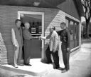
| Description: | Four men are standing at the door of the Chamber of Commerce on the corner of Oak and Broadway. One of the men is handing a set of keys to another man. |

| Date: | 04 1901 |
|---|---|
| Description: | A Sanborn map of Watertown, including an index and a key. |

| Date: | 10 1884 |
|---|---|
| Description: | A Sanborn map of Watertown, including the City Brewery and the Rock River. |

| Date: | 09 28 1914 |
|---|---|
| Description: | Town of Saales. Bombarded by the French on September 28. |
If you didn't find the material you searched for, our Library Reference Staff can help.
Call our reference desk at 608-264-6535 or email us at: