Filter: Categories of Wisconsin Historical Images
Filter: FORMAT_DIMENSIONS of unknown
Filter: Subject of cities and towns
Filter: Subject of lakes
Filter: Categories of Wisconsin Historical Images
Filter: FORMAT_DIMENSIONS of unknown
Filter: Subject of cities and towns
Filter: Subject of lakes

| Date: | |
|---|---|
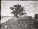
| Description: | The Eben Peck cabin was the first house built in Madison. |

| Date: | 1848 |
|---|---|
| Description: | In 1849, northern Wisconsin was composed of huge sectional regions such as Chippewa, Portage, Brown and Crawford, whereas southern Wisconsin was constitute... |

| Date: | 1861 |
|---|---|
| Description: | Drawn the first year of the Civil War, this colored 1861 map of Dane County shows its towns, cities and lakes. It includes insets of the wards of Madison a... |

| Date: | 1836 |
|---|---|
| Description: | The top map is the "Plat of Madison the Capitol of Wisconsin." The bottom map is the "Map of the Four Lake Country. Taken from the Township Maps in the U.S... |
| Date: | 11 20 1926 |
|---|---|
| Description: | View from Observatory Hill of the new Men's Lakeshore dormitories at the University of Wisconsin-Madison, showing Chamberlin Rock in the foreground. The do... |
| Date: | 1963 |
|---|---|
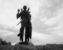
| Description: | Statue of Winnebago Indian Chief Red Bird, with Lake Winnebago in the background. |
| Date: | |
|---|---|
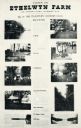
| Description: | Ethelwyn Farm (The Teachers' Country Club), on Lake Monona. |
| Date: | |
|---|---|
| Description: | Photographic print of an amateur painting of the Peck Cabin representing the "first house in Madison, Wisconsin." The "Peck Cabin" is a variation signed "M... |

| Date: | 1837 |
|---|---|
| Description: | Photographic print of an amateur painting, probably representing the "first house in Madison, Wisconsin." The Peck Cabin, one of the many free variations o... |
| Date: | 1863 |
|---|---|
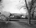
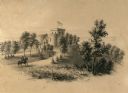
| Description: | A view overlooking the grounds towards the Benjamin Walker Castle, 1862-1893 in the 900 block of East Gorham Street, and its surrounding property. A man is... |
| Date: | 1863 |
|---|---|
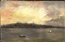
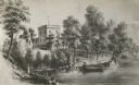
| Description: | View of the shoreline on the Walker Castle grounds. Two men are boating while a young boy fishes from the shore. |

| Date: | 1913 |
|---|---|
| Description: | A wall atlas of Sauk County, Wisconsin, displaying its 22 towns. On the left side are advertisements for local businesses. |

| Date: | 1860 |
|---|---|
| Description: | Stereograph of the Townsend House boathouse across a lake. |
| Date: | 1900 |
|---|---|
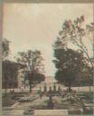
| Description: | Stereograph view toward Lake Monona from the State Capitol during the construction of the fourth capitol building. The image features the Capitol Square si... |

| Date: | 1873 |
|---|---|
| Description: | A hand-colored map of Minnesota, Wisconsin, and Michigan shows the counties, cities, villages, rivers, lakes, railroads, and steamboat routes in these stat... |

| Date: | 1982 |
|---|---|
| Description: | Color map. "Topography by photogrammetric methods from aerial photographs taken 1963. Revised from aerial photographs taken 1978. Field checked 1979. Map e... |

| Date: | |
|---|---|
| Description: | Detail from a drawing of a plan for the isthmus. |

| Date: | 1908 |
|---|---|
| Description: | Sanborn map of Madison, including West Gilman and Langdon Streets. |
If you didn't find the material you searched for, our Library Reference Staff can help.
Call our reference desk at 608-264-6535 or email us at: