Filter: Categories of Wisconsin Historical Images
Filter: FORMAT_DIMENSIONS of Unknown
Filter: Subject of cities and towns
Filter: Year of 1800-1899
Filter: Categories of Wisconsin Historical Images
Filter: FORMAT_DIMENSIONS of Unknown
Filter: Subject of cities and towns
Filter: Year of 1800-1899

| Date: | 02 21 1882 |
|---|---|
| Description: | Chromolithograph poster advertising a Milwaukee Mardi Gras celebration, arranged by the Turnverein and Milwaukee Musical Societies, and held at the Exposit... |
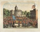
| Date: | 1857 |
|---|---|
| Description: | A lithographic portrait by Louis Kurz (1833-1921) of Madison Fire Engine Company #2 posed with a hand pumper and hose cart in front of the design of the ne... |
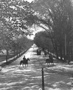
| Date: | 1896 |
|---|---|
| Description: | Tree-lined State Street from Bascom Hill on the University of Wisconsin-Madison campus. Traffic on State Street includes two well-dressed gentlemen on hors... |
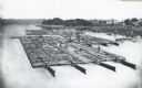
| Date: | 1870 |
|---|---|
| Description: | Elevated view of lumber raft and workers on the Chippewa River. In the background on the right are dwellings. |
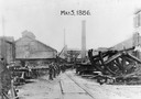
| Date: | 05 04 1886 |
|---|---|
| Description: | Edward P. Allis Reliance Works under the protection of the Wisconsin State Militia during the first general labor strike. The strike is also known as the ... |
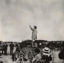
| Date: | 1897 |
|---|---|
| Description: | Robert M. La Follette, Sr., campaigning in Cumberland. La Follette led the reform faction in Wisconsin's Republican party and in 1900, he was elected gover... |
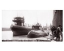
| Date: | 04 1893 |
|---|---|
| Description: | Captain Abe McDougall's whaleback boat, docked at the American Steel Barge Company. |
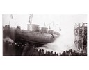
| Date: | 04 1893 |
|---|---|
| Description: | Launching Captain Abe McDougall's whaleback boat, "Christopher Columbus", from the American Steel Barge Company dock. |
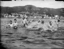
| Date: | 1890 |
|---|---|
| Description: | View across water towards men and boys swimming and splashing in the Mississippi River. Alma is in the background on the far shoreline. |
| Date: | 1883 |
|---|---|
| Description: | Tonyawatha Spring Hotel from a descriptive brochure. The hotel opened in 1879 and was destroyed by fire on July 31, 1895. |

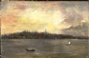
| Date: | 1848 |
|---|---|
| Description: | In 1849, northern Wisconsin was composed of huge sectional regions such as Chippewa, Portage, Brown and Crawford, whereas southern Wisconsin was constitute... |

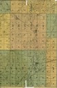
| Date: | 1861 |
|---|---|
| Description: | Drawn the first year of the Civil War, this colored 1861 map of Dane County shows its towns, cities and lakes. It includes insets of the wards of Madison a... |

| Date: | 1862 |
|---|---|
| Description: | Drawn the second year of the Civil War, this 1862 map of Milwaukee shows post offices, light houses, beacon lights, county buildings, elevator warehouses, ... |

| Date: | 1836 |
|---|---|
| Description: | The top map is the "Plat of Madison the Capitol of Wisconsin." The bottom map is the "Map of the Four Lake Country. Taken from the Township Maps in the U.S... |

| Date: | 1889 |
|---|---|
| Description: | Illustration of the exterior of the Fuller Opera House, which is a detail from a bird's-eye view map of Madison. |
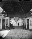
| Date: | 1877 |
|---|---|
| Description: | View towards men and women sitting and standing, beneath the lower deck of a suspension bridge (train uses upper deck). There are two booths (for tolls or ... |
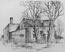
| Date: | 1850 |
|---|---|
| Description: | Strang House, also called "Mormon House," where "King" Strang lived and died, and where he published the Voree Herald. |

| Date: | 1889 |
|---|---|
| Description: | Chicago, Milwaukee & St. Paul passenger depot with several people standing in front of the building. This is the Franklin Street station on East Wilson Str... |
If you didn't find the material you searched for, our Library Reference Staff can help.
Call our reference desk at 608-264-6535 or email us at: