 Filter: Categories of Wisconsin Historical Images
Filter: FORMAT_DIMENSIONS of Unknown
Filter: County of Milwaukee
Filter: Year of 1800-1899
Filter: Categories of Wisconsin Historical Images
Filter: FORMAT_DIMENSIONS of Unknown
Filter: County of Milwaukee
Filter: Year of 1800-1899

| Date: | 02 21 1882 |
|---|---|
| Description: | Chromolithograph poster advertising a Milwaukee Mardi Gras celebration, arranged by the Turnverein and Milwaukee Musical Societies, and held at the Exposit... |
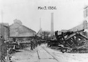
| Date: | 05 04 1886 |
|---|---|
| Description: | Edward P. Allis Reliance Works under the protection of the Wisconsin State Militia during the first general labor strike. The strike is also known as the ... |
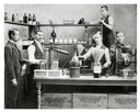
| Date: | 1896 |
|---|---|
| Description: | Workers posing in front of pharmaceutical equipment to demonstrate the making of Dr. Brown's Cough Balsam at Kienth Drugs and Medicines, 608 Mitchell Stree... |

| Date: | 1862 |
|---|---|
| Description: | Drawn the second year of the Civil War, this 1862 map of Milwaukee shows post offices, light houses, beacon lights, county buildings, elevator warehouses, ... |
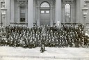
| Date: | 09 1887 |
|---|---|
| Description: | A group portrait of Civil War veterans and their families pose in front of the Milwaukee armory building at the reunion of The Iron Brigade. |
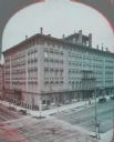
| Date: | 1880 |
|---|---|
| Description: | Stereograph of elevated view of Newhall House which was destroyed by fire in 1883. |
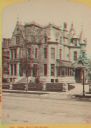
| Date: | 1874 |
|---|---|
| Description: | Stereograph of Broadway in Milwaukee. The mansion has many peaks on the roof, and the drive to the entrance is on the right. |
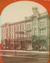
| Date: | 1886 |
|---|---|
| Description: | Stereograph. Located on Oneida Street, the opera house is three stories tall, and located across the street from a pharmacy (the Rx sign is hanging above t... |
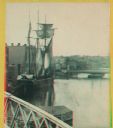
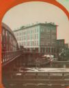
| Date: | 1880 |
|---|---|
| Description: | Stereograph. Part of a bridge is visible in the lower left corner. Under the bridge is a floating pier with advertisements painted on its sides. Another br... |

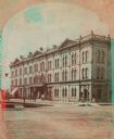
| Date: | 1866 |
|---|---|
| Description: | Stereograph. This building, which was destroyed by fire in 1866, was located in the commercial district known as Market Square. The Square was actually a t... |

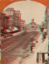
| Date: | 1875 |
|---|---|
| Description: | Stereograph of Wisconsin Street seen from Spring Street. The building on the left nearest the bridge was the Chicago, Milwaukee & St. Paul Railway's downto... |
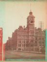
| Date: | 1870 |
|---|---|
| Description: | Stereograph; view of the earlier City Hall building, on Market Square at the corner of E. Water Street and Oneida Street. Several signs are in the image, i... |
| Date: | 1870 |
|---|---|
| Description: | Stereograph; view of store and adjoining buildings, Wisconsin and Milwaukee Streets. A large statue of a bird sits atop the store in the right of the image... |
| Date: | 1885 |
|---|---|
| Description: | Stereograph view of Chamber of Commerce at Broad and Michigan Streets. The building is the center of the image, with a telephone pole to the right, a larg... |
| Date: | 1869 |
|---|---|
| Description: | Stereograph of the Axtell House building, with a storefront next to it advertising "Clothing Hats Caps Sailors Outfits". A bridge is on the left and a man... |
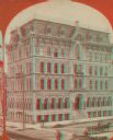
| Date: | 1890 |
|---|---|
| Description: | Stereograph; corner of Broad and Wisconsin Avenues. Built in 1870. E.T. Mix, architect. Victorian details decorate the six story building. A small pile of... |

| Date: | 1874 |
|---|---|
| Description: | Stereograph of elevated view looking northwest from Exposition Building. There is a church on a street corner on the left, and the Best Brewing Company in ... |

| Date: | 1894 |
|---|---|
| Description: | Sanborn map of Milwaukee, with the Milwaukee River on the left, and Water Street in the center. There are two iron draw bridges over the river. |
If you didn't find the material you searched for, our Library Reference Staff can help.
Call our reference desk at 608-264-6535 or email us at:

