Filter: Categories of Wisconsin Historical Images
Filter: FORMAT_DIMENSIONS of Unknown
Filter: Type of Map or Atlas
Filter: Subject of streets
Filter: Subject of dwellings
Filter: Categories of Wisconsin Historical Images
Filter: FORMAT_DIMENSIONS of Unknown
Filter: Type of Map or Atlas
Filter: Subject of streets
Filter: Subject of dwellings

| Date: | |
|---|---|
| Description: | This detailed map shows fortifications, headquarters, location and dates of battles, street outline of Atlanta, roads, railroads, vegetation, drainage, rel... |

| Date: | 1862 |
|---|---|
| Description: | This detailed map shows batteries and rifle pits, railroads, common and military roads, turnpikes, city streets and names, bridges, ferries, rural houses a... |
| Date: | 1900 |
|---|---|
| Description: | A Sanborn map of a portion of Seymour, Wisconsin. |

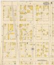
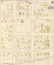
| Date: | 12 1912 |
|---|---|
| Description: | Sanborn map of Sun Prairie, which includes an index and information about water facilities and the fire department. Includes a small inset map of the State... |

| Date: | 12 1912 |
|---|---|
| Description: | Sanborn map of Sun Prairie, showing Main, Center and Church Streets. |

| Date: | 12 1912 |
|---|---|
| Description: | Sanborn Map of Sun Prairie. The map highlights the public and parochial schools, the exhange, and church buildings, etc. |
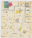
| Date: | 05 1894 |
|---|---|
| Description: | Sheet 2 of an Onalaska Sanborn map, including 2nd, 3rd, and 4th Streets. |
If you didn't find the material you searched for, our Library Reference Staff can help.
Call our reference desk at 608-264-6535 or email us at: