 Filter: Categories of Wisconsin Historical Images
Filter: FORMAT_DIMENSIONS of Unknown
Filter: Type of Map or Atlas
Filter: County of Milwaukee
Filter: Categories of Wisconsin Historical Images
Filter: FORMAT_DIMENSIONS of Unknown
Filter: Type of Map or Atlas
Filter: County of Milwaukee

| Date: | 1862 |
|---|---|
| Description: | Drawn the second year of the Civil War, this 1862 map of Milwaukee shows post offices, light houses, beacon lights, county buildings, elevator warehouses, ... |

| Date: | 1894 |
|---|---|
| Description: | Sanborn map of Milwaukee, with the Milwaukee River on the left, and Water Street in the center. There are two iron draw bridges over the river. |

| Date: | 1928 |
|---|---|
| Description: | This map shows a view of the Milwaukee metropolitan area. It highlights state trunk highways, principal county trunks and other secondary highways and type... |
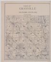
| Date: | 1920 |
|---|---|
| Description: | A plat map of the town of Granville in Milwaukee County, Wisconsin. |
If you didn't find the material you searched for, our Library Reference Staff can help.
Call our reference desk at 608-264-6535 or email us at:

