Filter: Categories of Wisconsin Historical Images
Filter: FORMAT_DIMENSIONS of 9.5 x 7.5 inches
Filter: Year of 1900-1999
Filter: Categories of Wisconsin Historical Images
Filter: FORMAT_DIMENSIONS of 9.5 x 7.5 inches
Filter: Year of 1900-1999

| Date: | 1951 |
|---|---|
| Description: | The Mack House, 110 East Johnson Street. The West wall of the house shows details on the gables and trim. Built by A.C. Isaac around 1870, it was later t... |
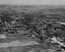
| Date: | 1925 |
|---|---|
| Description: | Aerial view of a neighborhood in Merrill. |
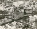
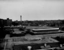
| Date: | 1965 |
|---|---|
| Description: | Aerial view, looking west, with potato warehouses in the foreground and a pallet factory and junkyard behind them at right. |
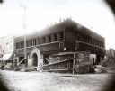
| Date: | 08 1911 |
|---|---|
| Description: | Exterior view of First National Bank under construction. |
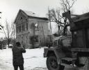
| Date: | 1970 |
|---|---|
| Description: | Mapleside, a historic home on University Avenue, being demolished. It is the future location of Burger King. |
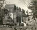
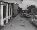
| Date: | 1948 |
|---|---|
| Description: | Abandoned mill, formerly called the Modena Roller Mills. The first mill was built in 1865 (now torn down). |

| Date: | 1973 |
|---|---|
| Description: | The Mears house, 420 North Carroll Street, built in 1871 for James Mears. |
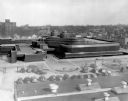
| Date: | 1940 |
|---|---|
| Description: | Elevated view of the S.C. Johnson & Son, Inc. building, designed by Frank Lloyd Wright. |
| Date: | 1948 |
|---|---|
| Description: | Exterior view of the S.C. Johnson & Sons, Inc. office building looking toward a parking lot. |
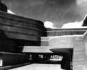
| Date: | 1949 |
|---|---|
| Description: | Elevated view of the Johnson Wax Administration Building taken at dusk with the circumferential bands of glass tubing lit. |
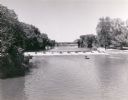
| Date: | 1960 |
|---|---|
| Description: | Slightly elevated view across water towards men fishing from a boat below the dam on the Fox River. Two other men are standing on the right shoreline near ... |
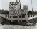
| Date: | 1920 |
|---|---|
| Description: | Detour sign posted by the Wisconsin Highway Commission, the predecessor of the Department of Transportation, in Manitowoc showing a confusing detour route ... |
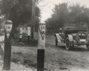
| Date: | 1917 |
|---|---|
| Description: | These two signs located along the route of Wisconsin State Trunk Highway 15 and 16 indicate the presence of a culvert. Beginning in 1917 Wisconsin pioneer... |
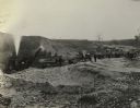
| Date: | 1920 |
|---|---|
| Description: | Dump trucks and steam shovel of the S.P. Croft Company, a road contractor from Milwaukee, at work at an unidentified Wisconsin site. |
| Date: | 1950 |
|---|---|
| Description: | Improved road paving equipment shown in an unidentified photograph. |
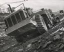
| Date: | 10 1959 |
|---|---|
| Description: | Construction of Interstate Highway I-94 in Waukesha County using an earthmover manufactured by Allis Chalmers. |

| Date: | 1960 |
|---|---|
| Description: | View of Ennis Lake, also known as Fountain Lake, located in the John Muir Memorial Park near Montello. As a boy, John Muir lived with his family on the sho... |

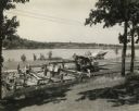
| Date: | 1960 |
|---|---|
| Description: | View of Ennis Lake, also known as Fountain Lake, located in the John Muir Memorial Park near Montello. As a boy, John Muir lived with his family on the sho... |
If you didn't find the material you searched for, our Library Reference Staff can help.
Call our reference desk at 608-264-6535 or email us at: