 Filter: Categories of Wisconsin Historical Images
Filter: FORMAT_DIMENSIONS of 8.5 x 11 inches
Filter: Year of 1900-1999
Filter: Subject of intellectual life
Filter: Year of 1930-1939
Filter: Categories of Wisconsin Historical Images
Filter: FORMAT_DIMENSIONS of 8.5 x 11 inches
Filter: Year of 1900-1999
Filter: Subject of intellectual life
Filter: Year of 1930-1939

| Date: | 07 1938 |
|---|---|
| Description: | Front cover of International Trail magazine featuring images of the expedition of Attilio Gatti to the Belgian Congo in Africa. Includes a color ill... |
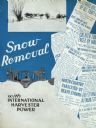
| Date: | 1935 |
|---|---|
| Description: | Cover of an International Harvester advertising catalog for snow removal equipment. An illustration depicts a man operating an industrial tractor equipped ... |

| Date: | 1936 |
|---|---|
| Description: | Cover of an advertising catalog for McCormick-Deering combines (harvester-threshers). Text on the cover reads: "Combines built for West Coast Growers: McCo... |

| Date: | 1938 |
|---|---|
| Description: | Cover of an advertising brochure with testimonial letters from International Harvester customers. Features a drawing of a man looking over the shoulder of ... |

| Date: | 1939 |
|---|---|
| Description: | Cover of an official program for the football game between the Green Bay Packers and the Chicago Cardinals played at Wisconsin State Fair Park. The cover f... |
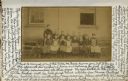
| Date: | 1935 |
|---|---|
| Description: | Vintage photograph, dated ca. 1890, with a wraparound handwritten message from Miss Louise Parke to her beloved teacher, Miss Mary L. Edgar, is part of a M... |
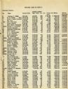
| Date: | 1935 |
|---|---|
| Description: | List of Juneau County landowners and details of the sale of their land to the United States Resettlement Administration. |
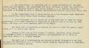
| Date: | 1935 |
|---|---|
| Description: | Page 2 of textual description of Brundage family and their resettlement from poor farmland to land better suited to agriculture. |

| Date: | 1937 |
|---|---|
| Description: | Map showing territory controlled by the Finches, a family of bandits who terrorized south central Wisconsin in the years prior to the Civil War. The map in... |

| Date: | 01 13 1937 |
|---|---|
| Description: | Sketch map of Township 7 North, Range 9 East, created for the Land Economic Inventory (Bordner Survey). The map shows Picnic Point and the Lake Mendota sho... |
If you didn't find the material you searched for, our Library Reference Staff can help.
Call our reference desk at 608-264-6535 or email us at: